Aptostichus angelinajolieae
| Notice: | This page is derived from the original publication listed below, whose author(s) should always be credited. Further contributors may edit and improve the content of this page and, consequently, need to be credited as well (see page history). Any assessment of factual correctness requires a careful review of the original article as well as of subsequent contributions.
If you are uncertain whether your planned contribution is correct or not, we suggest that you use the associated discussion page instead of editing the page directly. This page should be cited as follows (rationale):
Citation formats to copy and paste
BibTeX: @article{Bond2012ZooKeys252, RIS/ Endnote: TY - JOUR Wikipedia/ Citizendium: <ref name="Bond2012ZooKeys252">{{Citation See also the citation download page at the journal. |
Ordo: Araneae
Familia: Euctenizidae
Name
Aptostichus angelinajolieae Bond, 2008 – Wikispecies link – Angelina Jolie Trapdoor Spider’ ZooBank link – Pensoft Profile
Diagnosis
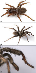
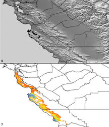
Individuals of this species are difficult to diagnose from Aptostichus atomarius and Aptostichus stanfordianus on the basis of morphological features alone (Figs 91–94) but can be diagnosed on the basis of a set of unique mtDNA site substitutions (see Bond & Stockman 2008). The species is restricted in distribution to northern Monterey Co. (California) localities west of the Salinas Valley (Maps 6, 7) and can be distinguished from geographically proximate populations of Aptostichus stephencolberti on the basis of its darker coloration (Figs 95–97) and absence from coastal dune habitat.
Descriptions
Described by Bond (2008).
Material examined
United States: California: Monterey Co.: 1.6km W Seaside, 36.6227, -121.83635, 30m, M Irwin 23.viii.68 [AP289, 3juv, AMNH]; 2.2km from intersection G16/Carmel Valley Rd & Cachagua Rds on Cachagua Rd, 36.4411, -121.68771, 387m, J Bond 5.v.97 [AP754-76, 2♀, AUMNH; 1♀, AMNH]; 24km W Greenfield on Arroyo-Seco Rd, 36.2263, -121.49475, 300m, W. Icenogle 31.v.74 [AP193, 2♀, CAS]; Aguajito Rd & Monhollan Rd jct, 36.5753, -121.87371, 56m, A Stockman 10.vi.05 [MY3317, 1♀, AMNH; MY3318, 3380 2♀, AUMNH]; Cachagua Rd, 160m W jct w/ Carmel Valley Rd, 36.4455, -121.68271, 191m, A Stockman 10.vi.05 [MY3311-13, 2juv, 2♀, AUMNH]; Cachagua Rd, 13.7km W jct w/ Carmel Valley Rd, 36.392, -121.62521, 333m, A Stockman 10.vi.05 [MY3315, 3316 2♀, AUMNH]; Cachagua Rd, just S intersection w/G16, 36.4447, -121.68551 1, 245m, M Hedin, J Starrett, D Leavitt 21.xii.07 [MY3620, 3626, 3627, 3630, 3631, 2♀ 1♂ 2juv, AUMNH]; Cachagua Rd, 160m from jct Carmel Valley Rd, 36.4454, -121.68331, 225m, J Bond, M van der Merwe 13.xii.99 [MY708, 716 2♀, AUMNH]; J Bond, M van der Merwe 13.xii.99 [MY716, 1♀, AUMNH]; Calera Canyon Rd, 1.6km S Corral De Tierra Rd, 36.5383, -121.73761, 137m, A Stockman 10.vi.05 [MY3319, 3321 2♀, AUMNH; MY3320, 1♀, AMNH]; Carmel, 36.5495, -121.91036, 74m, 25.vii.67 [AP155, 1♂, AMNH], 8.ii.54 [AP167, 1♂, AMNH], 5.x.58 [AP177, 1♂, AMNH], V Roth 21.xii.53 [AP267, 2juv, AMNH]; Carmel Valley Rd, 36.4511, -121.69191, 165m, A Stockman 15.v.05 [MY3129-3131 3♀, AUMNH]; Carmel Valley Rd (G16), 1.3km N Tassajara Rd, 36.4096, -121.59344, 426m, J Starrett 29.xi.03 [AP1198, 1♀, AUMNH]; Carmel Valley Rd/G16, 5.9km N Arroyo Seco Rd, 36.2904, -121.46591, 337m, A Stockman 9.vi.05 [MY3309, 3310 2♀, AUMNH]; County Rd G16, 17.7km S Martin Rd intersection, 36.2776, -121.45035, 335m, F Coyle 30.vii.72 [AP268, 1♀, AMNH]; Cachagua Rd 6.5 miles SE Carmel Valley Village, 4.2km S intersection w/Carmel Valley Rd, 36.4278, -121.68254, 460m, W Icenogle 2.vi.74 [AP279, 1♀, CAS]; G20 (Laureles Grade Rd), ~1.3km S Laureles Summit, 36.524, -121.75581, 315m, M Hedin, J Starrett, D Leavitt 21.xii.07 [MY3623, 3628 2♀, AUMNH]; Intersection of Valenzuela & Viejo Rds, 36.5761, -121.89981, 120m, J Bond 1.iv.96 [AP723, 727 1♀ 1juv, AUMNH], 2.iv.96 [AP742, 1♀, AUMNH], 5.v.97 [AP751, 752-3, 6, 2juv, 2♀, AUMNH]; Klondike Rd, 6.4km E G16/Carmel Valley Rd, 36.4731, -121.7071, 169m, J Bond, W Bond 27.vii.08 [MY3736, 1♀, AUMNH]; Monterey, ~100m N intersection Vieja & Valenzuela Rds, 36.5759, -121.89961, 91m, M Hedin, P Paquin, J Starrett 27.vii.02 [MY0632, 1♀, AUMNH]; Near jct Cachagua & Tassajara Rds, 36.3908, -121.59554, 410m, W Icenogle 2.vi.74 [AP277, 1♀, CAS]; Pacific Grove, 36.628, -121.92536, 30m, 7.xi.53 [AP163, 1♂, AMNH], W Ivie 1.ix.37 [AP274, 1juv, AMNH], 16.viii.31 [AP472, 1♀, 6juv, AMNH]; Palo Colorado Rd, 1.4km E Hwy 1, near Rocky Point, 36.3997, -121.89141, 105m, J Bond, A Stockman, D Beamer 17.iii.05 [MY3057, 3060, 2♀, AUMNH]; Pebble Beach, 36.5688, -121.94786, 25m, W Icenogle 1.vi.74 [AP291, 1♀, AMNH]; Sycamore Canyon Rd ~0.72km W jct HWY 1, 36.2418, -121.78411, 104m, J Bond 7.xii.05 [MY3452-54, 2♀ 1juv, AUMNH]; Viejo Rd, 36.5778, -121.900765, 138m, W Icenogle 1.vi.74 [AP197, 1♀, 3juv, CAS].
Variation, males (5). Cl 5.81-7.50, 6.30±0.31; Cw 5.00-6.19, 5.34±0.22; STRl 3.20-4.19, 3.49±0.18; STRw 2.70-3.27, 2.90±0.1; LBw 0.85-1.02, 0.94±0.04; LBl 0.43-0.63, 0.56±0.04; leg I: 5.25-6.44, 5.58±0.22; 3.50-4.25, 3.73±0.14; 3.65-4.44, 3.91±0.15; 2.25-2.61, 2.34±0.07; 1.75-2.55, 2.25±0.14; leg IV: 5.06-6.25, 5.43±0.28; 2.50-3.13, 2.81±0.13; PTl 2.51-3.00, 2.72±0.08; PTw 0.76-1.02, 0.89±0.04; Bl 1.19-1.49, 1.32±0.05; TSp 3-6, 4.20±0.58; TSr 3-5, 4.20±0.37; TSrd 4-5, 4.40±0.24.
Variation, females (5). Cl 6.69-8.96, 7.55±0.45; Cw 5.31-8.16, 6.50±0.53; STRl 3.75-5.70, 4.41±0.39; STRw 3.12-4.75, 3.70±0.33; LBw 1.07-1.55, 1.31±0.1; LBl 0.71-1.19, 0.93±0.08; Leg I: 14.56-20.94, 17.27±1.32; ANTd 6-8, 7.20±0.37; PTLs 14-17, 15.00±0.55; TBs 2-5, 3.00±0.55.
GenBank accessions
16S-tRNAval-12S: EU569940-EU569958, EU569991, JX103243-JX103249; 18S (partial)-ITS1-5.8S-ITS2: EU569880-EU569883.
Distribution and natural history
Aptostichus angelinajolieae is restricted in distribution to the Santa Lucia Range of Monterey County (Map 6), bounded to the east by the Salinas River Valley (SRV). The ecoregion is characterized as California Coastal Chaparral Forest and Shrub. As discussed in Bond and Stockman (2008)[1] the DM (Map 7) predicts the areas with the highest probability of occurrence in the regions east of the SRV, with the valley likely serving as a barrier to dispersal. The few male specimens known were collected during the late fall through winter months (October–December, February), with one specimen collected in July that molted to the final adult stage a month later in August. Female specimens are frequently found on shaded, damp steep banks and road cuts throughout the region. Burrows are generally shallow comprising a white silken lined retreat, covered by a thin silk-soil trapdoor.
Conservation status
The conservation status of Aptostichus angelinajolieae is likely classified as secure because it is widespread, abundant, and appears to thrive in moderately developed residential areas.
Species concept applied
Cohesion. Aptostichus angelinajolieae is considered a cohesion species on the basis of it exclusivity as a lineage in DNA studies and lack of genetic exchangeability (gene flow) with other Atomarius Sibling Species Complex lineages as a consequence of the SRV barrier to gene flow.
Taxon Treatment
- Bond, J; 2012: Phylogenetic treatment and taxonomic revision of the trapdoor spider genus Aptostichus Simon (Araneae, Mygalomorphae, Euctenizidae) ZooKeys, 252: 1-209. doi
Other References
- ↑ Bond J, Stockman A (2008) An Integrative Method for Delimiting Cohesion Species: Finding the Population-Species Interface in a Group of Californian Trapdoor Spiders with Extreme Genetic Divergence and Geographic Structuring. Systematic Biology 57: 628-646. doi: 10.1080/10635150802302443
Images
|
![Figures 91–94. Aptostichus angelinajolieae Bond, 2008. 91–93 male paratype from Monterey Co., Carmel (AP167); scale bars = 1.0mm 91 retrolateral aspect right leg I [805766] 92 prolateral aspect right leg I [805770] 93 retrolateral aspect pedipalp [805772] 94 cleared spermathecae, female holotype from Monterey Co., Carmel Valley (MY3310) [805773]; scale bar = 0.25mm.](https://species-id.net/o/thumb.php?f=ZooKeys-252-001-g022.jpg&width=250)

