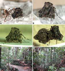
| ' Figure 1. Habitus and habitat images of species Archaeidae from north-eastern Queensland. A–D, Habitus images of live paratype specimens of Austrarchaea griswoldi sp. n. from Eungella National Park: A newly-moulted female with recently cast cuticle; B–C, female, lateral view; D, female carrying egg-sac. E–F, Habitat images: E, tropical rainforest at Broken River, Eungella National Park – type locality of Austrarchaea griswoldi sp. n.; F, dense tropical rainforest at Malaan National Park, Atherton Tableland – locality of Austrarchaea daviesae Forster & Platnick. |
| Figure 2. Map showing the known distribution of Archaeidae in Australia (circles for the genus Austrarchaea; squares for Zephyrarchaea), with locality records for north-eastern Queensland species of Austrarchaea in the Austrarchaea daviesae species-group highlighted in black. Note the three major biogeographic and phylogenetic disjunctions in the distribution of Australian Archaeidae (see Rix and Harvey 2012b[3]), especially the St Lawrence Gap, separating mid-eastern Australian taxa in the Austrarchaea nodosa species-group (see Figs 3–4). |
| Figure 3. Distribution and phylogeny of Austrarchaea species from Rix and Harvey (2011[1], 2012b[2]), showing the interrelationships of the three lineages from north-eastern Queensland (Austrarchaea daviesae species-group), mid-eastern Australia (Austrarchaea nodosa species-group) and the Gibraltar Range (Austrarchaea monteithi lineage), respectively. See Figure 4 for a comparison of morphological differences between these three clades. |
| Figure 4. Morphological differences between the three lineages of Austrarchaea (see Fig. 3). Note the variation in the shape of the male pedipalp and the marked differences in the shape and orientation of the conductor (C), embolus (E) and the distal tegular sclerites. Note also the number of abdominal hump-like tubercles (1-6): four in the Austrarchaea daviesae species-group; five in Austrarchaea monteithi; and six in the Austrarchaea nodosa species-group. |
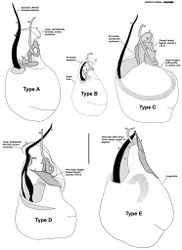
| Figure 6. Morphological differences between the five pedipalp types (Types A-E) identified for species of Austrarchaea from north-eastern Queensland, with left bulbs illustrated in ventral view at scale-identical sizes. Type A pedipalps are shared among at least five species from the Wet Tropics bioregion; Types B-E are autapomorphic for single species. Note especially the variation in the size and shape of the bulb, and the shape and orientation of the conductor. C = conductor; E = embolus; ESp = embolic spur; (TS)1-3 = tegular sclerites 1-3. Scale bar = 0.2 mm. |
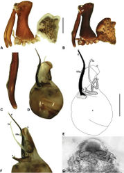
| Figure 7. Austrarchaea daviesae Forster & Platnick, 1984. A–B, Cephalothorax and abdomen, lateral view: A, female (WAM T125183) from Malaan National Park, Atherton Tableland, NE. Queensland; B, holotype male (QMB S1091) from Majors Mountain, Atherton Tableland, NE. Queensland. C, Holotype male chelicerae, lateral view, showing accessory setae. D–F, Male (WAM T125183; from Malaan National Park, Atherton Tableland, NE. Queensland) pedipalp: D–E, bulb, ventral view; F, detail of distal tegular sclerites, retrolateral view. G, Female (WAM T125183) internal genitalia, postero-ventral view (genital plate removed). C = conductor; E = embolus; T = tegulum; (TS)2-3 = tegular sclerites 2-3. Scale bars: A-B = 1.0 mm; E = 0.2 mm. |
| Figure 8. Austrarchaea wallacei sp. n. A–D, Holotype male (QMB S25964) from Mount Misery, Monkhouse Timber Reserve, NE. Queensland: A, cephalothorax and abdomen, lateral view; B, chelicerae, lateral view, showing accessory setae; C–D, right pedipalpal bulb (expanded; flipped horizontal for inter-specific comparison), retrolateral view. bH = basal haematodocha; C = conductor; E = embolus; ESp = embolic spur; H = haematodocha; T = tegulum; (TS)1-3 = tegular sclerites 1-3. Scale bars: A = 1.0 mm; D = 0.2 mm. |
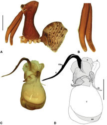
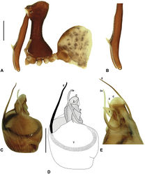
| Figure 9. Austrarchaea karenae sp. n. A–E, Holotype male (QMB S43060) from Windsor Tableland, Windsor Tableland National Park, NE. Queensland: A, cephalothorax and abdomen, lateral view; B, chelicerae, lateral view, showing accessory setae; C–D, pedipalpal bulb, ventral view; E, detail of distal tegular sclerites, retrolateral view. C = conductor; E = embolus; ESp = embolic spur; T = tegulum; (TS)1-3 = tegular sclerites 1-3. Scale bars: A = 1.0 mm; D = 0.2 mm. |
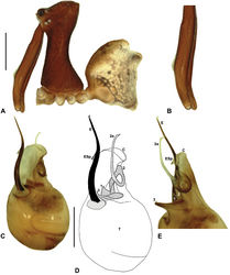
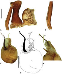
| Figure 10. Austrarchaea thompsoni sp. n. A–E, Holotype male (QMB S30840) from Devils Thumb, Daintree National Park, NE. Queensland: A, cephalothorax and abdomen, lateral view; B, chelicerae, lateral view, showing accessory setae; C–D, pedipalpal bulb, ventral view; E, detail of distal tegular sclerites, retrolateral view. C = conductor; E = embolus; ESp = embolic spur; T = tegulum; (TS)2-3 = tegular sclerites 2-3. Scale bars: A = 1.0 mm; D = 0.2 mm. |
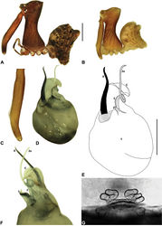
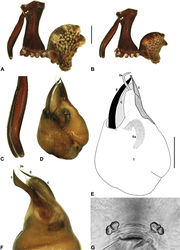
| Figure 11. Austrarchaea tealei sp. n. A–B, Cephalothorax and abdomen, lateral view: A, female (ANIC) from Mossman Gorge, Daintree National Park, NE. Queensland; B, holotype male (QMB S92210) from Mossman Gorge, Daintree National Park, NE. Queensland. C, Holotype male chelicerae, lateral view, showing accessory setae. D–F, Holotype male pedipalp: D–E, bulb, ventral view; F, detail of distal tegular sclerites, retrolateral view. G, Female (ANIC) internal genitalia, postero-ventral view (genital plate removed). C = conductor; E = embolus; ESp = embolic spur; T = tegulum; (TS)1-3 = tegular sclerites 1-3. Scale bars: A-B = 1.0 mm; E = 0.2 mm. |
| Figure 12. Austrarchaea westi sp. n. A–E, Holotype male (QMB S59537) from Mount Williams, Dinden National Park, NE. Queensland: A, cephalothorax and abdomen, lateral view; B, chelicerae, lateral view, showing lack of defined accessory setae; C–D, pedipalpal bulb, ventral view; E, detail of distal tegular sclerites, retrolateral view. C = conductor; E = embolus; T = tegulum; (TS)2-3 = tegular sclerites 2-3. Scale bars: A = 1.0 mm; D = 0.2 mm. |
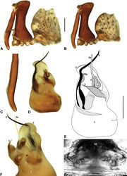
| Figure 13. Austrarchaea woodae sp. n. A–E, Holotype male (QMB S72988) from Boulder Caves, Mount Bartle Frere, Wooroonooran National Park, NE. Queensland: A, cephalothorax and abdomen, lateral view; B, chelicerae, lateral view, showing accessory setae; C–D, pedipalpal bulb, ventral view; E, detail of distal tegular sclerites, retrolateral view. C = conductor; E = embolus; T = tegulum; (TS)2-3 = tegular sclerites 2-3. Scale bars: A = 1.0 mm; D = 0.2 mm. |
| Figure 14. Austrarchaea hoskini sp. n. A–B, Cephalothorax and abdomen, lateral view: A, allotype female (QMB S17937) from Mount Elliot, Bowling Green Bay National Park, NE. Queensland; B, holotype male (QMB S30811) from Mount Elliot, Bowling Green Bay National Park, NE. Queensland. C, Holotype male chelicerae, lateral view, showing accessory setae. D–F, Holotype male pedipalp: D–E, bulb, ventral view; F, detail of distal tegular sclerites, retrolateral view. G, Allotype female internal genitalia, postero-ventral view (as seen through posterior rim of genital plate). C = conductor; E = embolus; ESp = embolic spur; GP = genital plate; T = tegulum; (TS)2-3 = tegular sclerites 2-3. Scale bars: A-B = 1.0 mm; E = 0.2 mm. |
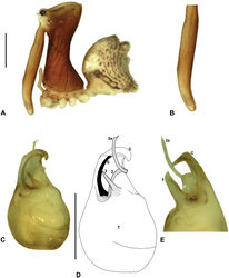
| Figure 15. Austrarchaea griswoldi sp. n. A–B, Cephalothorax and abdomen, lateral view: A, allotype female (QMB S92213) from Broken River, Eungella National Park, NE. Queensland; B, holotype male (QMB S92212) from Broken River, Eungella National Park, NE. Queensland. C, Holotype male chelicerae, lateral view, showing accessory setae. D–F, Holotype male pedipalp: D–E, bulb, ventral view; F, detail of distal tegular sclerites, retrolateral view. G, Allotype female internal genitalia, postero-ventral view (genital plate removed). C = conductor; E = embolus; Es = embolic sclerite; T = tegulum; (TS)1-3 = tegular sclerites 1-3. Scale bars: A-B = 1.0 mm; E = 0.2 mm. |
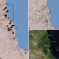
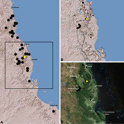
| Figure 16. Distribution of Austrarchaea daviesae Forster & Platnick, 1984: A, topographic map showing the known distribution of Archaeidae in the north-eastern Queensland Wet Tropics bioregion, with collection localities for Austrarchaea daviesae highlighted in yellow; B–C, topographic and satellite maps showing detail of inset (A). Labelled boundaries in (B) denote upland subregional zones of faunal endemism identified by Winter et al. (1984), Williams et al. (1996) and other authors for the central Wet Tropics (modified from Edward 2011). Small squares in (B–C) denote unidentified juvenile specimens; small circles denote unidentified female specimens; large circles denote described species of Austrarchaea. AU = Atherton Uplands; BK = Bellenden Ker/Bartle Frere; HI = Hinchinbrook Island; KU = Kirrama Uplands; LE = Lee Uplands; LU = Lamb Uplands; MT = Malbon-Thompson Uplands. |
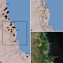
| Figure 17. Distribution of Austrarchaea wallacei sp. n.: A, topographic map showing the known distribution of Archaeidae in the north-eastern Queensland Wet Tropics bioregion, with collection localities for Austrarchaea wallacei highlighted in yellow; B–C, topographic and satellite maps showing detail of inset (A). Labelled boundaries in (B) denote upland subregional zones of faunal endemism identified by Winter et al. (1984), Williams et al. (1996) and other authors for the northern Wet Tropics (modified from Edward 2011). Small squares in (B–C) denote unidentified juvenile specimens; small circles denote unidentified female specimens; large circles denote described species of Austrarchaea. BM = Black Mountain Corridor; CU = Carbine Uplands; FU = Mt Finnigan Uplands; TU = Thornton Uplands; WU = Windsor Uplands. |
| Figure 18. Distribution of Austrarchaea karenae sp. n.: A, topographic map showing the known distribution of Archaeidae in the north-eastern Queensland Wet Tropics bioregion, with collection localities for Austrarchaea karenae highlighted in yellow; B–C, topographic and satellite maps showing detail of inset (A). Labelled boundaries in (B) denote upland subregional zones of faunal endemism identified by Winter et al. (1984), Williams et al. (1996) and other authors for the northern Wet Tropics (modified from Edward 2011). Small squares in (B–C) denote unidentified juvenile specimens; small circles denote unidentified female specimens; large circles denote described species of Austrarchaea. BM = Black Mountain Corridor; CU = Carbine Uplands; FU = Mt Finnigan Uplands; TU = Thornton Uplands; WU = Windsor Uplands. |
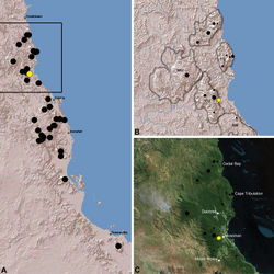
| Figure 19. Distribution of Austrarchaea thompsoni sp. n.: A, topographic map showing the known distrib ution of Archaeidae in the north-eastern Queensland Wet Tropics bioregion, with collection localities for Austrarchaea thompsoni highlighted in yellow; B–C, topographic and satellite maps showing detail of inset (A). Labelled boundaries in (B) denote upland subregional zones of faunal endemism identified by Winter et al. (1984), Williams et al. (1996) and other authors for the northern Wet Tropics (modified from Edward 2011). Small squares in (B–C) denote unidentified juvenile specimens; small circles denote unidentified female specimens; large circles denote described species of Austrarchaea. BM = Black Mountain Corridor; CU = Carbine Uplands; FU = Mt Finnigan Uplands; TU = Thornton Uplands; WU = Windsor Uplands. |
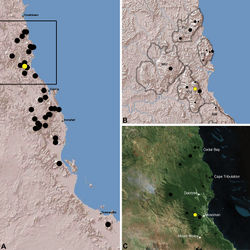
| Figure 20. Distribution of Austrarchaea tealei sp. n.: A, topographic map showing the known distribution of Archaeidae in the north-eastern Queensland Wet Tropics bioregion, with collection localities for Austrarchaea tealei highlighted in yellow; B-C, topographic and satellite maps showing detail of inset (A). Labelled boundaries in (B) denote upland subregional zones of faunal endemism identified by Winter et al. (1984), Williams et al. (1996) and other authors for the northern Wet Tropics (modified from Edward 2011). Small squares in (B–C) denote unidentified juvenile specimens; small circles denote unidentified female specimens; large circles denote described species of Austrarchaea. BM = Black Mountain Corridor; CU = Carbine Uplands; FU = Mt Finnigan Uplands; TU = Thornton Uplands; WU = Windsor Uplands. |
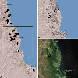
| Figure 21. Distribution of Austrarchaea westi sp. n.: A, topographic map showing the known distribution of Archaeidae in the north-eastern Queensland Wet Tropics bioregion, with collection localities for Austrarchaea westi highlighted in yellow; B-C, topographic and satellite maps showing detail of inset (A). Labelled boundaries in (B) denote upland subregional zones of faunal endemism identified by Winter et al. (1984), Williams et al. (1996) and other authors for the central Wet Tropics (modified from Edward 2011). Small squares in (B–C) denote unidentified juvenile specimens; small circles denote unidentified female specimens; large circles denote described species of Austrarchaea. AU = Atherton Uplands; BK = Bellenden Ker/Bartle Frere; HI = Hinchinbrook Island; KU = Kirrama Uplands; LE = Lee Uplands; LU = Lamb Uplands; MT = Malbon-Thompson Uplands. |
| Figure 22. Distribution of Austrarchaea woodae sp. n.: A, topographic map showing the known distribution of Archaeidae in the north-eastern Queensland Wet Tropics bioregion, with collection localities for Austrarchaea woodae highlighted in yellow; B–C, topographic and satellite maps showing detail of inset (A). Labelled boundaries in (B) denote upland subregional zones of faunal endemism identified by Winter et al. (1984), Williams et al. (1996) and other authors for the central Wet Tropics (modified from Edward 2011). Small squares in (B–C) denote unidentified juvenile specimens; small circles denote unidentified female specimens; large circles denote described species of Austrarchaea. AU = Atherton Uplands; BK = Bellenden Ker/Bartle Frere; HI = Hinchinbrook Island; KU = Kirrama Uplands; LE = Lee Uplands; LU = Lamb Uplands; MT = Malbon-Thompson Uplands. |
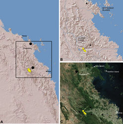
| Figure 23. Distribution of Austrarchaea hoskini sp. n.: A, topographic map showing the known distribution of Archaeidae in the north-eastern Queensland Wet Tropics bioregion, with collection localities for Austrarchaea hoskini highlighted in yellow; B–C, topographic and satellite maps showing detail of inset (A). Labelled boundaries in (B) denote upland subregional zones of faunal endemism identified by Winter et al. (1984), Williams et al. (1996) and other authors for the southern Wet Tropics (modified from Edward 2011). EU = Elliot Uplands; HU = Halifax Uplands. |
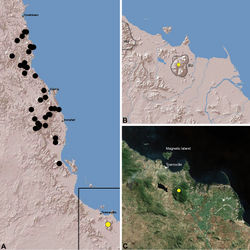
| Figure 24. Distribution of Austrarchaea griswoldi sp. n.: A, topographic map showing the known distribution of Archaeidae in the north-eastern Queensland Mackay and Whitsundays Hinterland, with collection localities for Austrarchaea griswoldi highlighted in yellow; B–C, topographic and satellite maps showing detail of inset (A). Small circles in (B–C) denote unidentified female specimens; large circles denote described species of Austrarchaea. |
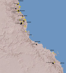
| ' Figure 25. Summary distribution of the Austrarchaea daviesae species-group in tropical north-eastern Queensland, showing collections records for described species (labelled, with black circles) and unidentified juveniles or females (yellow circles) (see Table 1). Note the high proportion of unidentified specimens, especially within the Wet Tropics bioregion between Cooktown and Ingham. |
|
![Figure 2. Map showing the known distribution of Archaeidae in Australia (circles for the genus Austrarchaea; squares for Zephyrarchaea), with locality records for north-eastern Queensland species of Austrarchaea in the Austrarchaea daviesae species-group highlighted in black. Note the three major biogeographic and phylogenetic disjunctions in the distribution of Australian Archaeidae (see Rix and Harvey 2012b[3]), especially the St Lawrence Gap, separating mid-eastern Australian taxa in the Austrarchaea nodosa species-group (see Figs 3–4).](https://species-id.net/o/thumb.php?f=ZooKeys-218-001-g002.jpg&width=250)
![Figure 3. Distribution and phylogeny of Austrarchaea species from Rix and Harvey (2011[1], 2012b[2]), showing the interrelationships of the three lineages from north-eastern Queensland (Austrarchaea daviesae species-group), mid-eastern Australia (Austrarchaea nodosa species-group) and the Gibraltar Range (Austrarchaea monteithi lineage), respectively. See Figure 4 for a comparison of morphological differences between these three clades.](https://species-id.net/o/thumb.php?f=ZooKeys-218-001-g003.jpg&width=250)

