Oosternum sharpi
| Notice: | This page is derived from the original publication listed below, whose author(s) should always be credited. Further contributors may edit and improve the content of this page and, consequently, need to be credited as well (see page history). Any assessment of factual correctness requires a careful review of the original article as well as of subsequent contributions.
If you are uncertain whether your planned contribution is correct or not, we suggest that you use the associated discussion page instead of editing the page directly. This page should be cited as follows (rationale):
Citation formats to copy and paste
BibTeX: @article{Deler-Hernández2014DeutscheEntomologischeZeitschrift61, RIS/ Endnote: TY - JOUR Wikipedia/ Citizendium: <ref name="Deler-Hernández2014Deutsche Entomologische Zeitschrift61">{{Citation See also the citation download page at the journal. |
Ordo: Coleoptera
Familia: Hydrophilidae
Genus: Oosternum
Name
Oosternum sharpi Hansen, 1999 – Wikispecies link – Pensoft Profile
- Oosternum costatum Sharp, 1882: 113 (secondary homonym of 'Megasternum costatum' LeConte, 1855).
- Oosternum sharpi Hansen, 1999: 242 (replacement name).
Material examined
(65 spec.). CUBA: Cienfuegos province: Cumanayagua municipality, Jardín Botánico de Cienfuegos, Soledad, ca. 73 m, 22°7’18.44”N, 80°19’35.26”W, 21.v.2013, A. Deler-Hernández leg., horse excrements (3 spec., NMPC); 01.v.1950, Acc. No 49672 (4 spec., WIFP); Mina Carlota, ca. 470 m, 22.0667°N, 80.1667°W, 06.v.1950, Acc. No 49681 (1 spec., WIFP). Camagüey province: Sierra de Cubitas municipality, Hoyo de Bonet, Res. Ecol. “Limones-Tuabaquey”, ca. 90 m a.s.l., 21°36’32.51”N, 77°47’5.30”W, 14.iv.2012, F. Cala-Riquelme & N. Duperré leg., (CU-20) (1 spec., NMPC). Granma province: PN Turquino track to Pico Turquino, ca. 900 m a.s.l., 20°0.5’N, 76°53.6’W, 29.iii.2012, F. Cala-Riquelme & N. Duperré leg., (CU03) (15 spec., NMPC). Santiago de Cuba province: San Luis municipality, El Vivero 1.6 Km E of Dos Caminos, ca. 150 m a.s.l., 20°10.8’N, 76°46.4’W, 20–21.vi.2012, A. Deler-Hernández & M. Fikáček leg., (MF18) (3 spec., NMPC); Km 7 road to Gran Piedra, ca. 550 m a.s.l., 20.011°N, 75.673°W, 26.i.2012, R. Anderson leg., (2012–007) (1 spec., NMPC). Guantánamo province: El Yunque, 0.5–1.0 Km W of campismo popular, ca. 40–50 m a.s.l., 20°20.1N 74°33.6W, 10.vi.2012, A. Deler-Hernández & M. Fikáček leg., (MF01) (1 spec., NMPC). HAITI: Port-au-Prince: 18°31’1.33”N, 72°20’7.42”W, 22.v.1950, Acc # 49650, H. B. Mills colr. (4 spec., WIFP). DOMINICAN REPUBLIC: Barahona: 7 Km NW Paraiso, ca. 200 m a.s.l., 17°59’06.85”N, 71°12’57.29”W, 27.xi/04.xii.1991, Masner & Peck leg., (91–341) (2 spec., SBPC); 1–04.xii.2012, Masner & Peck leg (91–358) (1 spec., SBPC). JAMAICA: Try Good Hope: ca. 145 m a.s.l., 18°25’N, 77°41’W, 17.viii.1966, H. F. Howden leg., (1 spec., SBPC); Trelawny Par. Nr. Windsor Caves, 18°20’59.21”N, 77°38’56.11”W, 24.iii.1991, T. K. Phillip and L. Gerofsky leg., berlese stream-side leaves (1 spec., WIFP). PUERTO RICO: 3.5 Km S Cabo Rojo, Cueva Tuna, ca. 25 m, 18°02’N, 67°09’W, 14.vi.1974, S. Peck leg., (1 spec., SBPC); Aguas Buenas, near Aguas Buenas Cave, ca. 250 m a.s.l., 18°15’N, 66°07’W, 07–17.v.1973, S. Peck leg., (1 male, SBPC); 2 km S Mamayes (Palmer), ca. 70 m, 18°21’13.63”N, 65°46’36.05”W, 25.IX.1987, M. Ivie, ex. old lawn debris (3 spec., WIFP); Isla Verde, vii/viii.1957, I. Fox lgt, light trap (1 spec., WIFP); El Verde, ca 250 m, 18°19’27.35”N, 65°49’26.90”W, M. A. Ivie lgt, at light (1 spec., WIFP). BARBADOS: Colescave: 1 Km SSE Welchman Hall, ca. 200 m a.s.l., 13°11’N, 59°34’W, 22–26.ii.1979, S. Peck leg., (3 spec., SBPC); Welchman Hall Gully, ca. 270 m a.s.l., 13°11.74’N, 59°34.60’W, 26.v.2006, S & P. Peck leg (06–60) (1 spec., SBPC). TRINIDAD & TOBAGO: Curupe: ca. 13 m a.s.l., 10°38’21.96”N, 61°24’35.91”W 05.xii.1977, W.R.M. Mason leg (1 spec., SBPC). SAINT LUCIA: Vieux Fort, ca. 3 m a.s.l., 13°43’18.68”N, 60°56’58.86”W, 12.vii.2007, S & P. Peck leg (07–60) (1 spec., SBPC). SABA: Neth Antil, ca. 384 m a.s.l., 17°37’43.45”N, 63°13’47.93”W, 20.V.2008, D. S. Sikes & M. A. Ivie leg, berlese litter/lawn clipping, (1 spec., WIFP). DOMINICA: Springfield Estate, ca. 330–360 m a.s.l., 15°20.796’N, 61°22.142’W, 30.v/16.vi.2004, S & P. Peck leg (04–86) (1 spec., SBPC). SAINT VINCENT AND GRENADINAS: Esmerald Valley Hotel, E. of Layou, ca. 20 m a.s.l., 13°12’N, 61°14.8’W, 27–29.viii.2006, S & J. Peck leg., forest edge UV, (06–123) (6 spec., SBPC); Buccament. Esmerald Valley Hotel, ca. 20 m a.s.l., 13°12’36.18”N, 61°13’47.74”W, 10–20.vi.2007, S & P. Peck leg (07–12) (1 spec., SBPC), Bequia island, Hamilton, ca. 25 m a.s.l., 13°00’30”N, 61°14’W, 01.viii.2008, S. Peck & M. de Silva leg (08–75) (1 spec., SBPC). GUADELOUPE: BT Malendure, Petite Trace, Fond Ravine, ca. 3 m a.s.l., 16°10.44’N, 61°46.7’W, 21.v.2012, S. Peck leg., forest edge UV, (12–31) (2 spec., SBPC). VIRGIN ISLAND: St. John, Dennis Bay, ca. 5 m, 18°21’7.08”N, 64°46’29.86”W, 16.vi.1980, (1 spec., WIFP); Maho Bay, ca 30 m, 18°21’41.92”N, 64°44’32.81”W, 12.iii.1984, W. B. colr, under trees near road, (1 spec., WIFP); St. Thomas, ca. 50 m, 18°21’20.93”N, 64°55’31.20”W, 05.viii.1984, (1 spec., WIFP).
Diagnosis
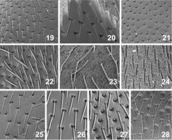
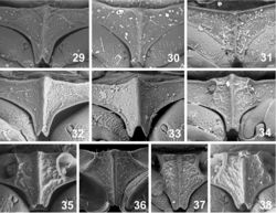
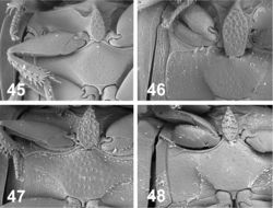
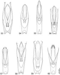
Body widest ca at midlength. Lateral margin of pronotum angulate. Pronotal punctation double-sized, dense consisting of moderately large, round punctures intermixed with smaller transverse punctures. Pronotal interstices with microsculpture. Mesal part of prosternum divided from lateral portions by oblique sharp ridges. Lateral margin of antennal grooves with acute projection. Elytral interval 2 narrower than interval 3, lower than intervals 1 and 3, reaching elytral apex. Elytral intervals 5, 7 and 9 distinctly higher than adjacent intervals. Elytral interstices shiny, without microsculpture. Preepisternal plate wide, drop-like, 2× longer than wide. Interstices of median part of metaventrite with very fine microsculpture, opaque. Anterolateral ridges not meeting together mesally. Parameres 1.2× longer than phallobase, bearing a single seta apically. Median lobe longer than parameres, narrowing towards apex. Membranous lateral projections of median lobe large, bearing long setae on each side.
Distribution
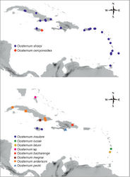
Oosternum sharpi is a common species distributed throughout the West Indies. We are recording it from all islands of the Greater Antilles (Cuba, Jamaica, Hispaniola and Puerto Rico) as well as from 9 islands of the Lesser Antilles. The species is otherwise widely distributed in southern USA, Central America and northern part of the South America, and was also introduced to the Azores (Orchymont 1940[1], Svensson 1973[2]), Hawaiian islands (Hansen 1995[3]), Ghana (Smetana 1978[4]) and Sri Lanka (Hansen 1995[3]). All specimens but one examined by us from the West Indian islands were females. The only male known from the West Indies is from Puerto Rico.
Habitat
Specimens of Oosternum sharpi are often collected from dry leaf litter of secondary forests or other secondary types of vegetation (including bamboo stands in agricultural areas), and are also found in cow and horse dung in the lowlands or occasionally attracted to UV light.
Taxon Treatment
- Deler-Hernández, A; Cala-Riquelme, F; Fikáček, M; 2014: A review of the genus Oosternum Sharp of the West Indies (Coleoptera: Hydrophilidae: Sphaeridiinae) Deutsche Entomologische Zeitschrift, 61(1): 43-63. doi
Images
|
Other References
- ↑ Orchymont A (1940) Les Palpicornia des îles atlantiques. Mémoires du Musée Royal dʼHistoire Naturelle de Belgique, 2ème Série 20: 1–86.
- ↑ Svensson B (1973) Report no 63 from the Lund University Expeditions in 1957 to the Azores and Madeira. Palpicornia (Coleoptera) from the Azores. Boletim do Museu Municipal do Funchal 27: 90–93.
- ↑ 3.0 3.1 Hansen M (1995) A Review of the Hawaiian Hydrophilidae (Coleoptera). Pacific Science 49(3): 266–288.
- ↑ Smetana A (1978) Revision of the subfamily Sphaeridiinae of America north of Mexico (Coleoptera: Hydrophilidae). Memoirs of the Entomological Society of Canada 105: 1–292. doi: 10.4039/entm110105fv

