Aphonopelma iodius
| Notice: | This page is derived from the original publication listed below, whose author(s) should always be credited. Further contributors may edit and improve the content of this page and, consequently, need to be credited as well (see page history). Any assessment of factual correctness requires a careful review of the original article as well as of subsequent contributions.
If you are uncertain whether your planned contribution is correct or not, we suggest that you use the associated discussion page instead of editing the page directly. This page should be cited as follows (rationale):
Citation formats to copy and paste
BibTeX: @article{Hamilton2016ZooKeys, RIS/ Endnote: TY - JOUR Wikipedia/ Citizendium: <ref name="Hamilton2016ZooKeys">{{Citation See also the citation download page at the journal. |
Ordo: Araneae
Familia: Theraphosidae
Genus: Aphonopelma
Name
Aphonopelma iodius (Chamberlin & Ivie, 1939) – Wikispecies link – Pensoft Profile
- Rhechostica iodius Raven, 1985: 149.
- Aphonopelma iodium Smith, 1995: 115.
- Aphonopelma iodium Prentice, 1997: 162.
- Aphonopelma iodius (spelling change; Platnick, World Spider Catalog)
- Aphonopelma angusi Smith, 1995: 72. previously synonymized by Prentice, 1997: 162.
- Aphonopelma melanium Smith, 1995: 120. previously synonymized by Prentice, 1997: 162.
- Aphonopelma nevadanum Smith, 1995: 125. previously synonymized by Prentice, 1997: 162.
- Rhechostica brunnius Raven, 1985: 149.
- Aphonopelma brunnium Smith, 1995: 79. syn. n.
- Rhechostica lithodomum Raven, 1985: 149.
- Aphonopelma lithodomum Smith, 1995: 119. syn. n.
- Rhechostica zionis Raven, 1985: 149.
- Aphonopelma zionis Smith, 1995: 157. syn. n.
Diagnosis
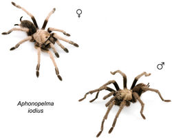
Aphonopelma iodius (Fig. 61) is a member of the iodius species group and can be identified by a combination of morphological, molecular, and geographic characteristics. Nuclear DNA identifies Aphonopelma iodius as a strongly supported lineage that is the sister lineage to Aphonopelma eutylenum, and paraphyletic with regards to the incipient species lineage Aphonopelma johnnycashi sp. n. (Fig. 8). There are no pronounced measurements or characters that help discriminate male or female Aphonopelma iodius from closely related phylogenetic species in the iodius species group, except for Aphonopelma johnnycashi sp. n., which is geographically and morphologically distinct. Males and females of Aphonopelma iodius can easily be differentiated from Aphonopelma steindachneri by their lighter color and greater extent of scopulation on metatarsi III and IV, and from syntopic members of the paloma species group (Aphonopelma atomicum sp. n., Aphonopelma icenoglei sp. n., Aphonopelma joshua, Aphonopelma mojave, and Aphonopelma prenticei sp. n.) by their larger size. Male Aphonopelma iodius possess a larger L3 scopulation extent (78%–96%) than Aphonopelma steindachneri (40%–54%), and a larger L4 scopulation extent (62%-88%) than Aphonopelma steindachneri (21%–31%). Female Aphonopelma iodius possess a larger L3 scopulation extent (72%–95%) than Aphonopelma steindachneri (51%–61%), and a larger L4 scopulation extent (59%–83%) than Aphonopelma steindachneri (24%–34%).
Description
Originally described by Chamberlin and Ivie (1939)[1].
Redescription of male exemplar
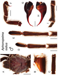
(APH_2015; Fig. 62). Specimen preparation and condition: Specimen collected live crossing road, preserved in 80% ethanol; deposited in AUMNH; original coloration faded due to preservation. Left legs I, III, IV, and left pedipalp removed for measurements and photographs; stored in vial with specimen. Right leg III removed for DNA and stored at -80°C in the AUMNH (Auburn, AL). General coloration: Black and faded brown. Cephalothorax: Carapace 16.14 mm long, 15.02 mm wide; Hirsute; densely clothed with light brown iridescent pubescence mostly appressed to surface; fringe covered in long setae not closely appressed to surface; foveal groove medium deep and straight; pars cephalica region rises gradually from foveal groove, gently arching anteriorly toward ocular area; AER slightly procurved, PER very slightly recurved; normal sized chelicerae; clypeus slightly extends forward on a curve; LBl 2.04, LBw 2.56; sternum hirsute, clothed with black, densely packed setae. Abdomen: Densely clothed in short black/brown pubescence with numerous longer red/orange setae interspersed; possessing a dense dorsal patch of black Type I urticating bristles (Cooke et al. 1972[2]). Legs: Hirsute, particularly ventrally; densely clothed in a mix of black or faded black pubescence, femurs are darker. Metatarsus I slightly curved. F1 16.56; F1w 4.02; P1 6.57; T1 14.65; M1 13.29; A1 8.96; F3 13.95; F3w 4.46; P3 5.58; T3 11.42; M3 13.91; A3 8.33; F4 16.27; F4w 3.86; P4 5.79; T4 13.82; M4 17.32; A4 9.16; femur III is slightly swollen. All tarsi fully scopulate. Extent of metatarsal scopulation: leg III (SC3) = 93.1%; leg IV (SC4) = 72.1%. One ventral spinose seta on metatarsus III; six ventral spinose setae on metatarsus IV; two prolateral spinose setae on tibia I. Coxa I: Prolateral surface a mix of fine, hair-like and tapered setae. Pedipalps: Hirsute; densely clothed in the same setal color as the other legs, with numerous longer ventral setae; one spinose seta on the apical, prolateral femur; two spinose setae on the prolateral patella; four spinose setae on the prolateral tibia; PTl 9.033, PTw 2.97. When extended, embolus tapers and gently curves to the retrolateral side near apex; embolus very slender, no keels. Variation (23). Cl 9.69–17.75 (13.959±0.45), Cw 8.51–16.49 (13.019±0.43), LBl 1.21–2.23 (1.734±0.06), LBw 1.397–2.56 (2.079±0.06), F1 10.336–16.69 (14.442±0.38), F1w 2.13–4.38 (3.326±0.12), P1 3.916–6.92 (5.704±0.16), T1 9.343–14.65 (12.294±0.28), M1 7.918–14.62 (11.76±0.34), A1 5.204–9.03 (7.508±0.21), L1 length 36.717–60.79 (51.709±1.33), F3 8.88–14.81 (12.472±0.34), F3w 2.27–4.51 (3.525±0.12), P3 3.248–6.39 (4.935±0.17), T3 6.934–11.84 (9.943±0.28), M3 8.446–14.28 (12.058±0.35), A3 5.067–8.63 (7.204±0.21), L3 length 32.69–54.63 (46.665±1.35), F4 10.308–17.21 (14.341±0.39), F4w 2.127–4.27 (3.258±0.12), P4 3.614–6.59 (5.277±0.17), T4 8.674–14.44 (12.274±0.31), M4 10.951–18.26 (15.385±0.4), A4 5.39–9.58 (7.96±0.24), L4 length 39.514–63.97 (55.346±1.51), PTl 6.198–10.293 (8.387±0.22), PTw 2.04–3.30 (2.687±0.07), SC3 ratio 0.789–0.961 (0.896±0.01), SC4 ratio 0.623–0.876 (0.746±0.01), Coxa I setae = thin tapered/tapered, F3 condition = normal/slightly swollen.
Description of female exemplar
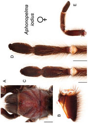
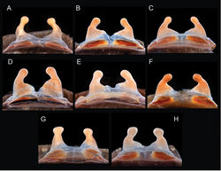
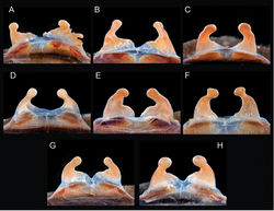
(APH_2016; Figs 63–66). Specimen preparation and condition: Specimen collected live from burrow, preserved in 80% ethanol; deposited in AUMNH; original coloration faded due to preservation. Left legs I, III, IV, and pedipalp removed for photographs and measurements; stored in vial with specimen. Right leg III removed for DNA and stored at -80°C in the AUMNH (Auburn, AL). Genital plate with spermathecae removed and cleared, stored in vial with specimen. General coloration: Faded brown/black. Cephalothorax: Carapace 18.71 mm long, 17.01 mm wide; Hirsute, densely clothed with light brown pubescence closely appressed to surface; fringe densely covered in longer setae; foveal groove medium deep and straight; pars cephalica region gently rises from thoracic furrow, arching anteriorly toward ocular area; AER slightly procurved, PER very slightly recurved; large chelicerae, clypeus extends forward on a curve; LBl 2.48, LBw 3.25; sternum very hirsute, clothed with dark brown setae. Abdomen: Densely clothed dorsally in short black setae with numerous longer, lighter setae interspersed (generally red or orange in situ); dense dorsal patch of black Type I urticating bristles (Cooke et al. 1972[2]); ventral side with shorter black/dark brown setae. Spermathecae: Paired and separate with wide bases, tapering and curving medially towards capitate bulbs. Legs: Very hirsute, particularly ventrally; densely clothed in medium and long brown pubescence, femurs darker. F1 15.37; F1w 4.45; P1 6.35; T1 11.57; M1 9.73; A1 7.40; F3 12.78; F3w 3.84; P3 5.79; T3 9.39; M3 9.85; A3 7.72; F4 15.23; F4w 4.28; P4 6.54; T4 11.62; M4 12.71; A4 8.91. All tarsi fully scopulate. Extent of metatarsal scopulation: leg III (SC3) = 87.8%; leg IV (SC4) = 81.4%. Three ventral spinose setae on metatarsus III; five ventral spinose setae on metatarsus IV. Coxa I: Prolateral surface a mix of fine, hair-like and medium tapered setae. Pedipalps: Densely clothed in the same setal color as the other legs; two spinose setae on the apical, prolateral femur, one spinose seta on the prolateral patella, and three spinose setae on the prolateral tibia. Variation (19). Cl 8.657–21.4 (15.619±0.68), Cw 7.51–18.6 (14.079±0.6), LBl 1.322–2.73 (2.086±0.09), LBw 1.578–3.25 (2.414±0.11), F1 7.493–16.71 (12.928±0.54), F1w 2.162–4.72 (3.69±0.16), P1 3.155–7.60 (5.581±0.26), T1 6.154–13.02 (10.428±0.41), M1 4.613–11.89 (8.701±0.43), A1 3.861–7.94 (6.577±0.24), L1 length 25.276–56.01 (44.214±1.84), F3 6.452–13.52 (11.003±0.42), F3w 1.923–4.02 (3.281±0.13), P3 2.599–6.65 (4.898±0.22), T3 4.381–10.07 (8.138±0.32), M3 4.766–11.50 (8.808±0.36), A3 3.978–7.72 (6.494±0.22), L3 length 22.176–48.63 (39.341±1.49), F4 7.32–17.23 (13.256±0.53), F4w 1.86–4.28 (3.405±0.14), P4 3.187–6.67 (5.289±0.21), T4 6.243–12.71 (10.466±0.39), M4 7.325–15.1 (12.038±0.43), A4 4.46–8.91 (7.111±0.22), L4 length 28.535–58.40 (48.161±1.72), SC3 ratio 0.724–0.949 (0.855±0.02), SC4 ratio 0.593–0.829 (0.739±0.02), Coxa I setae = tapered. Spermathecae variation can be seen in Figures 64–66.
Material examined
United States: Arizona: Coconino: House Rock - off 89A, 36.729414 -112.037386 5, 5337ft., [AUMS_3299, 3/7/89, 1♂, T.R. Prentice, AUMNH]; [AUMS_2386, 2/7/89, 1♂, T.R. Prentice, AUMNH]; off US-89A, Soap Creek Rd, 36.72439 -111.7556 1, 4211ft., [APH_0303, 8/10/07, 1 juv, Zach Valois, AUMNH]; Mohave: Road to Summit Springs, .25 miles from the UT/AZ border, 36.99566 -113.917793 4, 2533ft., [APH_2216, 19/10/1993, 1♂, T.R. Prentice, AMNH]; Beaver Dam Mountains, 0.3 miles S of UT/AZ border, 36.991946 -113.93678 4, 2450ft., [AUMS_3286, 6/10/93, 1♂, T.R. Prentice, AUMNH]; Beaver Dam Mountains, Rd to Summit Springs, Old Hwy 91, 36.985176 -113.920017 5, 2398ft., [APH_2218, 20/10/1993, 1♂, T.R. Prentice, AMNH]; Beaver Dam Mountains, Rd to Summit Springs, Old How 91, .2 miles south of UT/AZ line, 36.996269 -113.918282 5, 2520ft., [APH_2258, 6/10/93, 1♂, T.R. Prentice, AMNH]; California: Alameda: 5 miles SE of Livermore at jct. of Mines Rd. and Del Valle Rd., 37.62253 -121.7028 4, 784ft., [APH_0180-0182, 5/9/07, 1♀, 2♂, Gilbert Quintana, AUMNH]; Berkeley, 37.871593 -122.272747 5, 164ft., [APH_2459, 24/9/1935, 1♂, unknown, AMNH]; [APH_2460, 15/4/1936, 1♀, W.J. Baerg, AMNH]; Mines Rd, SE of Livermore, 37.5896 -121.6233 4, 1860ft., [APH_0404, 10/2008, 1♂, Mike Dame, AUMNH]; open area just SW jct Del Valle Rd and Mendenhall Rd [on trail along side of hill]; 37.604004 -121.686283 4, 1396ft., [APH_0104-0106, 6/5/07, 3♀, Mike Dame, AUMNH]; Contra Costa: Mt. Diablo State Park, 37.920733 -121.941483 1, 589ft., [APH_0985-0986, 9/2009, 1♀, 1♂, Kyle Dickerson, AUMNH]; [APH_0988-0989, 10/2009, 1♀, 1♂, Cody Will, AUMNH]; [APH_2150, 10/1966, 3♀, Pat Warner, AMNH]; [APH_2151, 10/1967, 1♂, Pat Warner, AMNH]; Mt. Diablo State Park, 1.35 miles E Mt Diablo Scenic Blvd on Summit Rd, 37.868743 -121.923839 2, 2640ft., [APH_0102-0103, 15/4/2007, 2♀, Mike Dame, AUMNH]; S of Antioch/Brentwood, Camino Diablo Rd and Vasco Rd, 37.865167 -121.668233 1, 114ft., [APH_2031, 10/2010, 1♂, Mike Marciano, AUMNH]; Fresno: Coalinga, 36.09221 -120.42766 5, 904ft., [APH_0307-0308, 11/9/07, 2♀, Gilbert Quintana, AUMNH]; Imperial: E of 78/N of Picacho State Recreation Area, on Black Mountain Rd, 33.08765 -114.85645 1, 1564ft., [APH_2028, 9/10/10, 1♂, Peter Scott, AUMNH]; E of 78/N of Picacho State Recreation Area, on Black Mountain Rd, S of 1128, 33.06294 -114.83999 1, 1849ft., [APH_2029, 9/10/10, 1♂, Peter Scott, AUMNH]; Hwy 78, 2/10 mile E of jct with Ogilby Road (S34); 33.088327 -114.907025 1, 1025ft., [APH_3212, 15/11/2013, 1♂, W. Icenogle, AUMNH]; Inyo: along Waucoba Rd, 37.14549 -118.13074 2, 6034ft., [APH_1242-1243, 15/10/2010, 2♂, Anette Pillau, AUMNH]; Death Valley National Park, Daylight Pass Rd, near mile 11 marker, Amargosa Mtns, 36.75975 -116.9308 1, 3660ft., [APH_1080, 3/10/10, 1♂, Chris A. Hamilton, AUMNH]; [APH_1083, 4/10/10, 1♀, Chris A. Hamilton, AUMNH]; Death Valley National Park, Emigrant Canyon Rd, Panamint Mtns, 36.42383 -117.19048 1, 4064ft., [APH_1078-1079, 3/10/10, 2♂, Chris A. Hamilton, AUMNH]; [APH_1081-1082, 4/10/10, 2♀, Chris A. Hamilton, AUMNH]; Death Valley National Park, Mesquite Spring Campground Rd, Amargosa Mtns, 36.97597 -117.36693 1, 1930ft., [APH_1084, 4/10/10, 1♂, Chris A. Hamilton, AUMNH]; Deep Springs Valley, E of summit of Westgard Pass, 37.331895 -118.037264 5, 5110ft., [AUMS_2351, 16/10/1976, 1♂, Frank Hovore, AUMNH]; Westgard Pass Road, 2.3 miles E of Big Pine, 37.204734 -118.242688 4, 4318ft., [AUMS_2450, 20/10/1993, 1♂, T.R. Prentice, AUMNH]; Kern: 1 mile S of Maricopa, 35.051693 -119.410088 5, 1000ft., [AUMS_2370, 7/12/69, 1♂, E.K. Slope, AUMNH]; 12 miles WNW McKittrick, Temblor Range, 35.34526 -119.80899 4, 3258ft., [APH_0045, 16/4/2000, 1 juv, James Pitts, AUMNH]; outside Rosamond, in hills N or Tropico; off Mojave-Tropico Rd, 34.88133 -118.23144 1, 2637ft., [APH_3103, 19/7/2012, 1♂, Chris Hamilton, Amy Skibiel, AUMNH]; Red Mountain, 20 Mule Team Rd., 9.5 miles E of Cal City, 35.194924 -117.774276 5, 2867ft., [AUMS_2380, 20/10/1994, 1♂, unknown, AUMNH]; 7.6 miles east of California City on 20 Mule Team Parkway, 35.161453 -117.863179 4, 2539ft., [APH_2223, 20/10/1994, 1♂, Thomas R. Prentice, AMNH]; Lassen: 0.5 miles S of Hwy 395, N of Honey Lake, where Smoke Creek Ranch Rd. joins Hwy 395, 40.425413 -120.279483 4, 4539ft., [AUMS_2672, 9/9/00, 1♀, Stephan Wiley, AUMNH]; Los Angeles: Lang, 34.44549 -118.37372 5, 1862ft., [APH_0592, 13/6/2009, 1 juv, Anette Pillau, AUMNH]; E of Hi Vista, Avenue G, 34.734973 -117.765229 5, 3028ft., [APH_2720, 10/11/1963, 1♂, Geo. R. Wilson, AMNH]; Mono: Benton, 37.819199 -118.474701 5, 5410ft., [APH_2676, 27/9/1941, 1♂, L.A. Hart, AMNH]; [APH_2679, 7/10/43, 1♂, W.M. Pearce, AMNH]; Monterey: Arroyo Seco, foothills of Santa Lucia Range, 36.238772 -121.480529 5, 977ft., [AUMS_2489, 6/11/87, 1♀, T.R. Prentice, AUMNH]; Carmel, 36.555239 -121.923288 5, 233ft., [APH_2815, 6/1/54, 1♂, unknown, AMNH]; Carmel Valley, 36.479925 -121.7328 5, 410ft., [APH_2713, 11/1944, 1♂, Fred E. Samson, AMNH]; [APH_2718, 6/10/53, 1♂, unknown, AMNH]; dry valley 14 miles southeast of Monterey, 36.471026 -121.702876 5, 850ft., [APH_2471, unknown, 1♂, E. Ricketts, AMNH]; Hastings Natural History Reservation, Robles del Rio, 36.367998 -121.563616 5, 1542ft., [APH_2698, unknown, 1♂, Linsdale, AMNH]; [APH_2714, unknown, 1♂, Linsdale, AMNH]; [APH_2721, unknown, 1♂, Linsdale, AMNH]; Los Laureles Grade Road, southeast of Monterey, 36.518052 -121.756652 5, 768ft., [APH_2696, 8/10/66, 1♂, P. Warner, AMNH]; Santa Lucia Range - Los Padres NF, Arroyo Seco (Campground); 36.231711 -121.485187 5, 944ft., [AUMS_3306, 6/11/87, 1♂, T.R. Prentice, AUMNH]; Lake Nacimiento, along Nacimiento Lake Dr. (Co. Hwy G14); west of Camp Roberts, W of San Miguel, 35.69067 -120.79972 1, 1007ft., [APH_2041, 7/12/11, 1 juv, Chris A. Hamilton, Jason Bond, AUMNH]; Lake Nacimiento, on Vista Rd at junction with Nacimiento Lake Dr. (Co. Road 19); west of Camp Roberts, W of San Miguel, 35.79395 -120.8727 1, 646ft., [APH_2042, 7/12/11, 1♀, Chris A. Hamilton, Jason Bond, AUMNH]; Riverside: 3 miles W of I-10 off Hwy 177, 33.705262 -115.451685 5, 1110ft., [AUMS_3326, 8/10/89, 1♀, T.R. Prentice, AUMNH]; Hexie Mountains, 33.830162 -115.983601 6, 3812ft., [APH_2220, 16/4/1989, 1♀, T.R. Prentice, AMNH]; Joshua Tree National Monument, Pinto Basin, 33.925009 -115.700823 5, 1538ft., [AUMS_2371, 10/1962, 1♂, Van Hoose and Rainey, AUMNH]; Joshua Tree National Monument, west of Hidden Valley picnic area, 34.010251 -116.173413 5, 4163ft., [APH_2228, 5/8/87, 1♀, T.R. Prentice, AMNH]; Joshua Tree National Park, Cottonwood Springs area, 33.74139 -115.811471 1, 3112ft., [APH_1500-1501, 5/9/12, 2♂, Brent E. Hendrixson, AUMNH]; [APH_2235, 25/2/1985, 1♂, T.R. Prentice, AMNH]; [APH_2240, 4/4/89, 1♀, T.R. Prentice, AMNH]; Joshua Tree National Park, first roadside pullout stop from west entrance along Quail Springs Rd, along trail, 34.07156 -116.23954 4, 4040ft., [APH_0332-0334, 8/5/08, 3 juv, Brent E. Hendrixson, Zach Valois, AUMNH]; Joshua Tree National Park, near Cottonwood Campground, 33.740358 -115.812362 1, 3046ft., [APH_1327, 31/7/2011, 1♀, Brent E. Hendrixson, Brendon Barnes, Nate Davis, Jake Storms, AUMNH]; Joshua Tree National Park, off El Dorado Mine Rd/Cottonwood Springs Rd, 1/2 mile N of Porcupine Wash, 33.84946 -115.78205 1, 2386ft., [APH_1008, 10/5/10, 1♀, Chris A. Hamilton, AUMNH]; Joshua Tree National Park, on service rd to maintenance area, off El Dorado Mine Rd, 34.02212 -116.01233 1, 3624ft., [APH_1005-1006, 10/5/10, 2♀, Chris A. Hamilton, AUMNH]; Joshua Tree National Park, picnic area, Covington Flats area, 34.027454 -116.30194 1, 4656ft., [APH_0491, 16/5/2009, 1 juv, Brent E. Hendrixson, Bernadette DeRussy, Sloan Click, Jason Bond, AUMNH]; [APH_1198, 29/7/2010, 1♂, Brent E. Hendrixson, Brendon Barnes, Nate Davis, AUMNH]; Joshua Tree National Park, S border, 3.4 miles E of Cottonwood Springs Rd, 33.66753 -115.726563 4, 1750ft., [AUMS_2684, 23/8/1993, 1♀, T.R. Prentice, AUMNH]; near Red Cloud Mine, 33.621745 -115.463815 6, 2068ft., [AUMS_2369, 25/10/1963, 1♂, unknown, AUMNH]; Orocopia Mtns, Joshua Tree National Monument exit, 33.613298 -115.853258 5, 2108ft., [AUMS_3288, 16/12/1989, 1♂, T.R. Prentice, AUMNH]; Pleasant Valley, Joshua Tree National Park, 33.914434 -116.052056 5, 3292ft., [AUMS_2683, 27/8/1966, 1♂, unknown, AUMNH]; Quail Springs Rd (National Park Drive); 3 miles NW of picnic area, 2.7 miles SE of monument entrance, Joshua Tree National Park, 34.068483 -116.235733 4, 3976ft., [APH_2247, 3/8/89, 1♂, T.R. Prentice, AMNH]; West Palm Springs Village, Cottonwood Rd, 1.4 miles N of I-10, San Bernardino Mtns, 33.938417 -116.697217 1, 1621ft., [APH_3136, 20/9/2013, 1♂, W. Icenogle, AUMNH]; Whitewater Canyon Rd area NW of Palm Springs, 33.965967 -116.651917 1, 1896ft., [APH_2036-2037, 7/27/11, 1♂, 1♀, Warren Burke, AUMNH]; Whitewater Canyon Rd, 3 miles N of junction with I-10, San Bernardino Mtns, 33.96385 -116.65105 1, 1878ft., [APH_3135, 8/9/13, 1♂, W. Icenogle, AUMNH]; San Benito: E of Hollister, off Quien Sabe Rd, E of Tres Pinos, 36.80288 -121.30323 1, 805ft., [APH_2001-2003, 10/10/10, 3♂, Chris A. Hamilton, RJ Adams, AUMNH]; Hwy 25, 1.5 miles N of Pinnacles turn off, old Horace Bacon Ranch, 36.535996 -121.148339 5, 1309ft., [AUMS_2495, 8/11/87, 1♀, T.R. Prentice, AUMNH]; just E of Hwy-25, vicinity of Pinnacles National Monument, 36.49367 -121.06376 2, 1842ft., [APH_0151, unknown, 1 juv, T.R. Prentice, AUMNH]; Pinnacles N. Mon., .25 miles S of Hwy 25, 36.517091 -121.13235 4, 1197ft., [AUMS_2500, 7/11/87, 1♀, T.R. Prentice, AUMNH]; Pinnacles N. Mon., 8 miles N of turnoff from Hwy 25, 36.48708 -121.21392 4, 1458ft., [AUMS_2508, 7/11/87, 2♂, T.R. Prentice, AUMNH]; Pinnacles, old Horace Bacon Ranch, 1.5 miles NE of Pinnacles, 36.535699 -121.148194 5, 1310ft., [AUMS_2494, 8/11/87, 1♀, T.R. Prentice, AUMNH]; San Bernardino: 10 miles south of Barstow on Hwy 247, 34.754995 -117.007841 5, 2877ft., [APH_2252, 7/11/91, 1♂, T.R. Prentice, AMNH]; Coxcomb Mountains, 8 miles west of Hwy 62, 33.990731 -115.430123 5, 3402ft., [APH_2230, 4/2/90, 1♀, T.R. Prentice, AMNH]; NE slope of Coxcomb Mountains, 8 miles west of Hwy 62, 34.048671 -115.335004 5, 1614ft., [APH_2227, 4/2/90, 1♀, T.R. Prentice, AMNH]; Reche Rd, 4.5 miles east of Landers, 34.265929 -116.304316 4, 2730ft., [APH_2242, 18/10/1981, 1♂, W. Icenogle, AMNH]; 1.1 miles NE Lucerne Valley Cutoff along Hwy-247 (Barstow Rd); 34.614513 -116.968992 1, 3239ft., [APH_0758-0759, 5/10/09, 2 juv, Brent E. Hendrixson, Thomas Martin, AUMNH]; 11 miles north of Buelton, 34.677234 -120.157748 5, 745ft., [APH_2701, 23/9/1965, 1♂, Jean and Wilton Ivie, AMNH]; 2.6 miles S Phelan Rd on Baldy Mesa Rd, 34.389973 -117.454903 1, 3974ft., [APH_1575-1576, 6/11/12, 2 juv, Brent E. Hendrixson, AUMNH]; 3-4 miles E of Milpas Dr. Hwy, 18 miles S of Hwy by power lines, 34.525984 -116.984374 5, 3028ft., [AUMS_2521, 28/10/1989, 1♂, T.R. Prentice, AUMNH]; 36 miles E of Joshua Tree National Monument headquarters, 34.124371 -115.408958 5, 1548ft., [AUMS_2540, 12/11/89, 1♂, T.R. Prentice, AUMNH]; along Hwy-62, west of Coxcomb Mountains, 34.113767 -115.496503 1, 2252ft., [APH_1582-1583, 7/11/12, 1♂, 1 juv, Brent E. Hendrixson, AUMNH]; Apple Valley, 34.500666 -117.172078 5, 2943ft., [AUMS_3312, 07/1973, 1♂, R. Estrada, AUMNH]; Coxcomb Mountains, 0.3 miles N of JTNM Boundary, 34.002853 -115.426675 4, 1892ft., [AUMS_2537, 24/11/1989, 1♂, T.R. Prentice, AUMNH]; E of Twentynine Palms, off Hwy 62 - N side of road, near Joshua Tree National Park, 34.11838 -115.89557 1, 1660ft., [APH_3157-3160, 10/11/13, 2♂, 2 juv, Chris A. Hamilton, Brent E. Hendrixson, Molly Taylor, AUMNH]; Hesperia, 2.5 miles S Phelan Rd on Baldy Mesa Rd, 34.389771 -117.453406 1, 3692ft., [APH_1326, 31/7/2011, 1 juv, Brent E. Hendrixson, Brendon Barnes, Nate Davis, Jake Storms, AUMNH]; Honda Road, 34.111948 -116.461021 6, 3403ft., [AUMS_2524, 14/4/1991, 1♀, T.R. Prentice, AUMNH]; Joshua Tree National Monument, W of small picnic area, Quail Mtn. area, 33.97058 -116.299793 5, 3977ft., [AUMS_2467, 10/8/89, 1♂, T.R. Prentice, AUMNH]; Lucerne Valley, Hwy 18 - 3 miles SE Hwy 247, High Desert, 34.423672 -116.918691 5, 3077ft., [AUMS_2381, 1/11/89, 1♂, T.R. Prentice, AUMNH]; off Hwy 247, N of Lucerne Valley, 34.53291 -116.9397 1, 2850ft., [APH_3145, 10/11/13, 1♀, Chris A. Hamilton, Brent E. Hendrixson, Molly Taylor, AUMNH]; 3.6 miles W of Nipton on Nipton Rd., 35.45746 -115.3346 1, 2665ft., [APH_0318, 6/5/08, 1 juv, Brent E. Hendrixson, Zach Valois, Stephen Rash, AUMNH]; Halloran Summit Road, 0.3 miles N I-15, 35.407038 -115.795374 1, 4079ft., [APH_0515, 21/5/2009, 1♀, Brent E. Hendrixson, Bernadette DeRussy, Sloan Click, AUMNH]; Kingston Range, Excelsior Mine Rd, 35.71268 -115.79702 2, 3601ft., [APH_1642, 26/11/2012, 1 juv, Matt Graham, AUMNH]; 100 yards N Havasu Lake Road, 2 miles SE of jct with Hwy 95, 34.532801 -114.624968 1, 1670ft., [APH_3201, 11/11/13, 1♀, W. Icenogle, AUMNH]; Eastern slope of Whipple Mountains, Black Landing road across from Gene Wash reservoir, 34.346101 -114.205737 5, 588ft., [AUMS_3310, 4/2/90, 1♀, T.R. Prentice, AUMNH]; Hwy 95, ~8 miles N of jct with Havasu lake Road, S of Lobecks Pass, 34.672525 -114.625747 1, 1578ft., [APH_3202, 16/11/2013, 1♂, W. Icenogle, AUMNH]; near Needles, on River Road, 2.5 miles S of I-40, 34.794722 -114.608835 5, 725ft., [AUMS_2349, 22/10/1976, 1♂, W. Icenogle, AUMNH]; off Hwy 62, W of Parker (Whipple Mtns); 34.2131 -114.42914 1, 987ft., [APH_1004, 9/5/10, 1♀, Chris A. Hamilton, AUMNH]; 3.1 miles east of Kramer Jct on Hwy 56, 34.983798 -117.484214 4, 2414ft., [APH_2250, 8/11/92, 1♂, Thomas R. Prentice, AMNH]; East Mojave Desert, Mid Hills near Providence Mountain , 35.22291 -115.457469 6, 4429ft., [APH_2222, 13/5/1989, 1♂, Thomas R. Prentice, AMNH]; Kelso-Cina Rd, 11.5 miles north of Kelso, 35.135929 -115.530791 4, 3382ft., [APH_2236, 1/11/92, 1♂, Thomas R. Prentice, AMNH]; Kelso-Cina Rd, 6.3 miles north of Kelso, 35.083174 -115.567666 4, 2926ft., [APH_2251, 1/11/92, 1♂, Thomas R. Prentice, AMNH]; Red Mountain, 1 mile west of Powerline Rd. , 35.357912 -117.623138 5, 3664ft., [APH_2233, 26/10/1991, 1♂, Thomas R. Prentice, AMNH]; [APH_2234, 13/10/1992, 1♂, Thomas R. Prentice, AMNH]; Red Mountain, 1.5 miles west of Hwy 395, 35.358458 -117.640062 4, 3937ft., [APH_2237, 20/10/1991, 1♂, Thomas R. Prentice, AMNH]; Red Mountain, 1.5 miles west of Powerline rd., 35.352194 -117.606607 4, 3802ft., [APH_2221, 13/10/1991, 1♀, Thomas R. Prentice, AMNH]; Red Mountain, 19 miles north of Kramer Junction, 1.5 miles west of Hwy 395, 35.361421 -117.621001 5, 3694ft., [APH_2255, 13/10/1992, 1♀, Thomas R. Prentice, AMNH]; Red Mountain, 19 miles north of Kramer Junction, off Hwy 395, 35.353665 -117.617923 5, 3589ft., [APH_2238, 14/10/1991, 1♀, Thomas R. Prentice, AMNH]; [APH_2239, 12/10/1991, 1♀, Thomas R. Prentice, AMNH]; [APH_2241, 26/10/1991, 1♂, Thomas R. Prentice, AMNH]; [APH_2246, 20/10/1991, 1♂, Thomas R. Prentice, AMNH]; Red Mountain, 20 miles north of Kramer Jct, 1.5 miles west of Hwy 395, 35.363666 -117.623444 5, 3694ft., [APH_2256, 22/1/1994, 1♀, Thomas R. Prentice, AMNH]; Red Mountain, 20 miles north of Kramer Jct, on Power Rd, 35.361066 -117.615155 5, 3602ft., [APH_2243, 26/10/1991, 1♂, Thomas R. Prentice, AMNH]; Red Mountain, off Hwy 395, 35.36059 -117.615889 6, 3664ft., [APH_2231, 14/10/1991, 1♀, Thomas R. Prentice, AMNH]; East Mojave, Black Canyon Rd., 2 miles N of Essex Rd. jct., 34.937755 -115.413054 4, 3180ft., [AUMS_2372, 25/10/1992, 1♂, Thomas R. Prentice, AUMNH]; Red Mountain, 35.316678 -117.591078 6, 3164ft., [AUMS_2353, 14/10/1991, 1♀, Tom Prentice, AUMNH]; Red Mountain, ~19 miles N of Kramer Junction, 35.271452 -117.630077 5, 3220ft., [AUMS_2373, 3/10/92, 1♀, Thomas R. Prentice, AUMNH]; [AUMS_2375, 13/10/1991, 1♂, Thomas R. Prentice, AUMNH]; Red Mountain, ~19 miles N of Kramer Junction - Hwy 395, power line rd., 35.262031 -117.612309 5, 3059ft., [AUMS_2374, 3/10/92, 1♂, Thomas R. Prentice, AUMNH]; Red Mountain, ~19 miles N of Kramer Junction, 0.4 W of powerline, 35.250499 -117.616993 5, 3000ft., [AUMS_2378, 20/10/1991, 1♂, Thomas R. Prentice, AUMNH]; Red Mountain, 0.6 miles 20 Mule Team Rd., 35.251471 -117.617676 4, 3011ft., [AUMS_2377, 20/10/1991, 1♂, Thomas R. Prentice, AUMNH]; Red Mountain, 1 mile W of power line rd., 35.296474 -117.6267 5, 3230ft., [AUMS_2346, 26/10/1991, 1♂, Thomas R. Prentice, AUMNH]; Red Mountain, 19 miles N of Kramer Junction off Hwy 395, power line rd., 35.266359 -117.612937 5, 3081ft., [AUMS_2343, 17/10/1992, 1♂, Thomas R. Prentice, AUMNH]; Red Mountain, 19 miles N of Kramer Junction with 20 Mule Team Rd, 35.265871 -117.613745 5, 3081ft., [AUMS_2365, 19/10/1994, 1♂, Thomas R. Prentice, AUMNH]; Red Mountain, 3.6 miles W of power line road, on 20 Mule Team Rd., 35.25059 -117.620344 4, 3008ft., [AUMS_2342, 10/10/92, 1♂, Thomas R. Prentice, AUMNH]; Red Mountain, power line rd., mining mounds, 35.329506 -117.611623 5, 3364ft., [AUMS_2341, 20/10/1991, 1♂, Thomas R. Prentice, AUMNH]; 0.4 miles north of Covington Flats entrance, 34.04764 -116.316153 4, 4619ft., [APH_2229, 10/8/89, 1♂, T.R. Prentice, AMNH]; San Joaquin: Tracy - Carnegie SVRA, 37.653867 -121.627067 1, 1553ft., [APH_0990, 10/2009, 1♂, Cody Will, AUMNH]; San Luis Obispo: 7 miles northeast of Cholame, 35.774731 -120.181254 5, 1693ft., [APH_2671, 31/8/1958, 1♂, V. Roth, AMNH]; 7 miles NW of Paso Robles - Lake Nacimiento, 35.690839 -120.801114 5, 1108ft., [AUMS_2579, 10/1996, 1♂, Andrew Walters, AUMNH]; Chimineas Ranch, 35.17554 -120.01147 4, 2383ft., [APH_0078-0083, 25/3/2007, 1♂, 2♀, 3 juv, Alice Abela, AUMNH]; Cayucos, approx. 4 miles E on Old Creek Road, 35.47548 -120.85584 4, 297ft., [APH_0016, 15/8/2002, 1♂, Kelly C. Carroll, AUMNH]; E of Santa Maria, Hwy 166, 35.01671 -120.33505 1, 722ft., [APH_1092-1094, 9/10/10, 2♂, 1♀, Chris A. Hamilton, AUMNH]; Poly Canyon, California Polytechnic Univ., San Luis Obispo, 35.31598 -120.65632 4, 701ft., [APH_0077, 22/10/2006, 1 juv, Alice Abela, AUMNH]; San Mateo: 1000 block of Porto Marino Dr, San Carlos, 37.488576 -122.274238 2, 254ft., [APH_1371, 9/2011, 1♂, Julie Pitre, AUMNH]; Jasper Ridge, 37.40524 -122.2421 5, 417ft., [APH_2477, 13/11/1921, 1♀, 4♂, 1 juv, C.D. Duncan, AMNH]; Santa Barbara: 12 miles northeast of Los Olivos near Zaca Park, 34.722266 -120.035831 5, 1296ft., [APH_2709, 29/7/1961, 1♂, Roth and Roth, AMNH]; 5 miles south of Buelton, 34.560664 -120.190635 5, 564ft., [APH_2682, 23/9/1965, 1♂, Jean and Wilton Ivie, AMNH]; Figueroa Mountain Road, 34.72249 -119.96665 4, 4043ft., [APH_0036, 4/9/06, 1♂, Alice Abela, AUMNH]; [APH_0039-0040, 4/9/06, 2 juv, Alice Abela, AUMNH]; NE of Buellton, E on 154 at Hwy 101 split, 34.68066 -120.15461 1, 785ft., [APH_1091, 9/10/10, 1♀, Chris A. Hamilton, AUMNH]; Sycamore Canyon area, along Figueroa Mountain Rd, 34.727447 -120.098169 4, 1160ft., [APH_0418, 20/9/2008, 1♂, Anette Pillau, AUMNH]; Santa Clara: 0.37 miles SW jct Mines Rd on San Antonio Valley Rd, 37.4005 -121.4918 2, 2240ft., [APH_0407, 10/2008, 1♀, Mike Dame, AUMNH]; Mount Hamilton Area, 37.37888 -121.81057 4, 526ft., [APH_0051, 24/8/2001, 1 juv, Katrina Couch, Jerami Myers, AUMNH]; Palo Alto, 37.441872 -122.143006 5, 30ft., [APH_2695, Spring 1922, 1♂, R.W. Doane, AMNH]; Stanford, 37.424106 -122.166076 5, 92ft., [APH_2672, 1905, 1♀, unknown, AMNH]; Stanislaus: 0.06 miles W jct Adobe Canyon Rd on Del Puerto Canyon Rd, 37.4085 -121.4102 2, 1340ft., [APH_0405, 10/2008, 1♂, Mike Dame, AUMNH]; Del Puerto Canyon Rd, 37.4 -121.4438 4, 2050ft., [APH_0406, 10/2008, 1♂, Mike Dame, AUMNH]; Del Puerto Canyon, 25 miles west of Patterson, 37.42119 -121.374632 5, 1188ft., [APH_2677, 23/9/1967, 1♂, W.J. Turner, AMNH]; Frank Raines Park, 37.419831 -121.370933 1, 1200ft., [APH_2030, 10/2010, 1♀, Mike Dame, AUMNH]; Henry W Coe State Park, 37.18823 -121.54585 1, 2749ft., [APH_1095-1099, 10/10/10, 3♂, 2♀, Chris A. Hamilton, RJ Adams, AUMNH]; [APH_2000, 10/10/10, 1♂, Chris A. Hamilton, RJ Adams, AUMNH]; Nevada: Clark: 0.3 miles N Hwy-161 along dirt road, between Jean and Goodsprings, 35.81268 -115.38099 1, 3370ft., [APH_0358-0359, 12/5/08, 2 juv, Brent E. Hendrixson, Zach Valois, AUMNH]; 1.9 miles E Hwy-160 on Trout Canyon Rd, 36.122811 -115.817589 1, 3463ft., [APH_1208-1210, 31/7/2010, 3 juv, Brent E. Hendrixson, Brendon Barnes, Nate Davis, AUMNH]; 10 miles east of Las Vegas, 36.178731 -114.873725 5, 1447ft., [APH_2274, 07/1955, 1♂, W.J. Gertsch, AMNH]; 17-19 miles SE of Pahrump on Hwy 160, 36.029949 -115.702158 5, 3566ft., [APH_2224, 11/10/74, 1♂, W. Icenogle, AMNH]; 4.6 miles W US-95 (Searchlight) on Hwy-164, 35.488073 -114.996602 1, 3690ft., [APH_1220, 2/8/10, 1♀, Brent E. Hendrixson, Brendon Barnes, Nate Davis, AUMNH]; 7.7 miles W Searchlight on Hwy-164, 35.50444 -115.04914 1, 4057ft., [APH_0751, 3/10/09, 1♂, Brent E. Hendrixson, Thomas Martin, AUMNH]; 8.2 miles west of Searchlight, 2 miles north of Hwy 164, 35.496212 -115.213376 4, 4665ft., [APH_2248, 7/10/89, 1♀, T.R. Prentice, AMNH]; 8.2 miles west of Searchlight, on Hwy 164, 35.508562 -115.066862 4, 4249ft., [APH_2253, 7/10/89, 1♂, T.R. Prentice, AMNH]; along dirt road S of Hwy-95, 36.56321 -115.881585 1, 3701ft., [APH_1215, 1/8/10, 1♀, Brent E. Hendrixson, Brendon Barnes, Nate Davis, AUMNH]; Boulder City and Hemenway Wash, 36.020585 -114.80798 5, 1575ft., [APH_2458, 10/1939, 5♂, B.E. Rees, AMNH]; Desert National Wildlife Refuge, open desert N of Mormon Well Rd, approx. 3 miles W Alamo Rd, 36.435992 -115.351558 2, 2968ft., [APH_0476, 13/5/2009, 1 juv, Brent E. Hendrixson, Bernadette DeRussy, Sloan Click, Jason Bond, AUMNH]; Goodsprings, 35.832479 -115.434165 5, 3707ft., [APH_2731, 22/12/1946, 1♂, J.C. Madsen, AMNH]; Indian Springs, 1.5 miles WSW US-95 on Cold Creek Rd (near Southern Desert Correction Center); 36.51153 -115.570812 4, 3454ft., [APH_0183, 12/9/07, 1♂, Tim Filson, AUMNH]; [APH_0184, 8/8/07, 1♀, Tim Filson, AUMNH]; Muddy Mountains, 36.36485 -114.70364 2, 2851ft., [APH_1634, 10/11/12, 1 juv, Matt Graham, AUMNH]; Pahrump Rd, 17 to 19 miles SE of Pahrump, 36.04757 -115.726851 5, 3375ft., [AUMS_2608, 11/10/74, 1♀, W. Icenogle, AUMNH]; SE of Pahrump, Trout Canyon Rd, 36.12301 -115.82007 1, 3441ft., [APH_1075-1077, 2/10/10, 1♂, 2♀, Chris A. Hamilton, AUMNH]; Searchlight, 3 miles south on Hwy 95, 35.418906 -114.907457 5, 3176ft., [APH_2245, 2/10/81, 1♂, W. Icenogle, AMNH]; Christmas Tree Pass, Spirit Mtn, Lake Mead NRA, 35.26086 -114.73926 1, 3887ft., [APH_0313, 12/10/07, 1♀, Rick C. West, AUMNH]; [APH_0517, 24/5/2009, 1♀, Brent E. Hendrixson, Rick C. West, Bernadette DeRussy, AUMNH]; [APH_0996-0998, 6/5/10, 3♀, Chris A. Hamilton, Rick West, AUMNH]; Searchlight, 8.2 miles west on Hwy 164 in the foothills of highlands, 35.49844 -115.056633 4, 4108ft., [APH_2261, 7/10/89, 1♀, T.R. Prentice, AMNH]; Lincoln: 8.3 miles S Alamo Canyon Rd on Hwy-93, 37.224912 -115.082582 1, 3160ft., [APH_0782, 9/10/09, 1 juv, Brent E. Hendrixson, Thomas Martin, AUMNH]; Pioche, 37.929818 -114.451689 5, 6063ft., [APH_2728, 10/1941, 1♂, Mrs. Dibble, AMNH]; Nye: 0.8 miles S Hwy-95 along Rd-552, 36.582225 -115.944177 1, 3728ft., [APH_1547, 23/10/2012, 1 juv, Brent E. Hendrixson, AUMNH]; Mercury, 36.66051 -115.994475 5, 3796ft., [APH_2724, 1962, 1♂, Gertsch, AMNH]; [APH_2726, 16/10/1961, 1♂, unknown, AMNH]; [APH_2729, 10/11/60, 1♂, Gertsch, AMNH]; [APH_2732, 9/10/61, 1♂, unknown, AMNH]; White Pine: Ely, 39.247265 -114.88863 5, 6437ft., [APH_2619, 24/8/1952, 1♂, unknown, AMNH]; Utah: Beaver: Wah Wah Springs, 38.503218 -113.472862 5, 5233ft., [APH_2270, 07/1940, 1♂, unknown, AMNH]; unknown, 38.326633 -113.28705 7, 6214ft., [APH_2272, 25/8/1946, 1♂, Chamberlin and Ivie, AMNH]; Box Elder: Brigham City, 41.510213 -112.015502 6, 4439ft., [APH_2283, 1927, 2♂, unknown, AMNH]; Honeyville, approx. 2 miles E I-15 at foothills of mtns, 41.63333 -112.04894 4, 5516ft., [APH_0006, 29/8/2004, 1♂, Andrea Strange, AUMNH]; Cache: Sardine Canyon, 41.581309 -111.932847 5, 4993ft., [APH_2734, 9/1947, 1♂, unknown, AMNH]; Davis: Centerville, 40.918 -111.87216 5, 4393ft., [APH_2269, 3/10/36, 1♂, unknown, AMNH]; Duchesne: Lower part of City Creek Canal, 40.202984 -110.413946 5, 5640ft., [APH_2280, 21/9/1942, 1♂, Wilton Ivie, AMNH]; Millard: W of Delta on Hwy 6/50, E of House Range Mtns around Antelope Springs Rd and Steamboat Springs Rd, 39.05897 -113.24963 1, 4784ft., [APH_2015, 23/9/2010, 1♂, Kelly Parr, AUMNH]; [APH_2016, 14/10/2010, 1♀, Chris A. Hamilton, AUMNH]; White Valley, 38.378831 -113.706023 5, 5682ft., [APH_2271, 12/8/40, 1♂, Chamberlin and Ivie, AMNH]; Piute: Marysvale, 38.44942 -112.2302 5, 5892ft., [APH_2736, 8/8/48, 1♂, Edw. Cormolly, AMNH]; Salt Lake: Big Cottonwood Canyon, 0.9 miles E Wasatch Blvd on UT-190, 40.62078 -111.77369 1, 5200ft., [APH_0050, 14/7/2006, 1♀, Brent E. Hendrixson, AUMNH]; Bluffdale, ~3 miles W I-15 on 14600 S, 40.48621 -111.91835 4, 4466ft., [APH_0004, 10/10/04, 1♂, Tiffany Blanchard, AUMNH]; East of Holladay, 40.671407 -111.782393 6, 5650ft., [APH_2267, 25/8/1941, 1♂, Chamberlin and Ivie, AMNH]; Mill Creek Canyon, 40.69001 -111.777132 5, 5240ft., [APH_2738, 08/1928, 1♂, R.V. Chamberlin, AMNH]; Mill Creek Canyon, Wasatch Mountains, 40.690695 -111.773522 5, 5249ft., [APH_2268, 5/8/42, 1♂, Chamberlin and Ivie, AMNH]; [APH_2277, 12/9/45, 1♂, Willis M. Creer, AMNH]; N Salt Lake City , 40.86167 -111.892803 6, 4902ft., [APH_2263, 210/2008, 2♂, unknown, AMNH]; Salt Lake City, 40.727231 -112.039815 6, 4245ft., [APH_2207, unknown, 2♂, unknown, AMNH]; [APH_2265, 22/9/1941, 4♂, Chamberlin and Ivie, AMNH]; [APH_2266, 08/1939, 2♂, unknown, AMNH]; [APH_2273, 10/1933, 1♂, unknown, AMNH]; Salt Lake City, Bonneville Shoreline Trail, 40.763 -111.82 2, 5210ft., [APH_0788-0789, 28/8/2009, 2♂, Will Black, AUMNH]; unknown, 40.644188 -111.952249 7, 4409ft., [APH_2262, 1934, 3♂, unknown, AMNH]; San Juan: San Juan Bulge, 1/2 mile below Mexican Hat, 37.147965 -109.866298 5, 4114ft., [APH_2737, 18/7/1947, 1♀, Harold Higgins, AMNH]; Sevier: Oak Creek Canyon, 38.526922 -111.85269 5, 6998ft., [APH_2735, 24/8/1968, 1♂, G.F. Knowetn, AMNH]; Tooele: S of Delle, off I-80, 40.68329 -112.88853 2, 4920ft., [APH_0790, 17/10/2009, 1♂, DeAnn Neal, AUMNH]; South Mountain, 40.4651111 -112.4826666 5, 5406ft., [APH_0163, 19/8/2007, 1♂, Brian Nielsen, AUMNH]; South Willow Canyon, 40.5093342 -112.5349121 5, 5679ft., [APH_0161, 2/8/07, 1♂, Brian Nielsen, AUMNH]; [APH_0162, 9/8/07, 1♂, Brian Nielsen, AUMNH]; Stansbury Mountains, 40.5097653 -112.5324224 5, 5797ft., [APH_0155, 13/7/2007, 1♂, Brian Nielsen, AUMNH]; Stockton, 40.452722 -112.360782 6, 5121ft., [APH_2264, 1918, 2♂, unknown, AMNH]; Wendover, 40.737095 -114.03751 5, 4295ft., [APH_2733, 15/9/1942, 1♂, Don Nieleson, AMNH]; Utah: Box Elder Canyon, 40.473006 -111.750208 5, 5548ft., [APH_2739, 2/10/47, 2♂, S. H. Jenaera, AMNH]; Washington: 1 mile N of La Verkin, 37.230736 -113.271966 4, 3245ft., [APH_2282, 12/10/39, 1♂, unknown, AMNH]; 10 miles south of Enterprise, 37.450725 -113.63881 5, 5791ft., [APH_2279, 14/10/1939, 1♂, unknown, AMNH]; Beaver Dam Mountains, 37.0764081 -113.8702196 5, 4026ft., [APH_0154, 13/7/2007, 1♂, Brian Nielsen, AUMNH]; Beaver Dam Mountains, 0.5 miles W, 37.077649 -113.872749 6, 4135ft., [AUMS_2468, 1993, 1♀, T.R. Prentice, AUMNH]; Beaver Dam Mountains, near Bulldog Knolls, 37.0184842 -113.8854744 5, 3086ft., [APH_0157, 13/7/2007, 1♀, Brian Nielsen, AUMNH]; Beaver Dam Mountains, Old Highway-91, 37.05399 -113.894229 5, 3445ft., [APH_0453, 11/10/06, 1♂, Brian Nielsen, AUMNH]; Beaver Dam Mountains, Old Hwy 91, 1.2 miles N of Utah/AZ line, 37.016981 -113.909332 4, 2960ft., [AUMS_2347, 12/10/93, 1♀, T.R. Prentice, AUMNH]; Beaver Dam Mountains, Rd to Summit Springs, Old Hwy 91, 37.028247 -113.90558 5, 3038ft., [APH_2217, 6/10/93, 1♂, T.R. Prentice, AMNH]; [APH_2225, 19/10/1993, 1♂, T.R. Prentice, AMNH]; Beaver Dam Mountains, Rd to Summit Springs, Old Hwy 91, .2 miles north of UT/AZ line, 37.003736 -113.914265 5, 2635ft., [APH_2249, 19/10/1993, 1♂, T.R. Prentice, AMNH]; Beaver Dam Mountains, Rd to Summit Springs, Old Hwy 91, 1.7 miles north of UT/AZ line, 37.018438 -113.908722 5, 2884ft., [APH_2244, 19/10/1993, 1♂, T.R. Prentice, AMNH]; Beaver Dam Mountains, Rd to Summit Springs, Old Hwy 91, 2.5 miles north of UT/AZ line, 37.017035 -113.909593 5, 2520ft., [APH_2259, 12/10/93, 1♂, T.R. Prentice, AMNH]; Beaver Dam Mountains, Rd to Summit Springs, Old Hwy 91, 2.6 miles north of UT/AZ line, 37.036118 -113.902906 5, 3169ft., [APH_2257, 19/10/1993, 1♂, T.R. Prentice, AMNH]; Beaver Dam Mountains, Summit Spring, near Old Hwy-91, 37.088438 -113.871915 1, 4297ft., [APH_0779, 8/10/09, 1 juv, Brent E. Hendrixson, Thomas Martin, AUMNH]; Beaver Dam Mountains, Summit Springs, 37.066177 -113.885856 5, 3865ft., [APH_2254, 4/7/89, 1♂, T.R. Prentice, AMNH]; [APH_2260, 16/9/1989, 1♂, T.R. Prentice, AMNH]; [AUMS_3320, 5/10/95, 1♂, T.R. Prentice, AUMNH]; Enterprise, 37.573587 -113.719133 5, 5322ft., [APH_2284, 20/9/1939, 1♂, Ronn Hardy, AMNH]; Entrance to Zion National Park, 37.200215 -112.990135 5, 4006ft., [APH_2278, 16/8/1925, 1♂, A.M. Woodbury, AMNH]; just outside Zion National Park, Smith Mesa Road, 37.290592 -113.112587 5, 5230ft., [AUMS_2696, 22/8/1991, 1♀, 1♂, T.R. Prentice, AUMNH]; just outside Zion National Park, Smith Mesa Road, 37.289355 -113.114065 5, 5230ft., [AUMS_2698, 23/8/1991, 1♂, T.R. Prentice, AUMNH]; near Beaver Dam Mountains, 37.168672 -113.964461 6, 4852ft., [APH_2214, 10/1931, 1♂, A.M. Woodbury, AMNH]; near Gunlock, 37.2465941 -113.7766128 5, 3664ft., [APH_0153, 13/7/2007, 1♂, Brian Nielsen, AUMNH]; on Smith Mesa Rd., 1.2 miles W of junction with Kolob Reservoir Rd., 37.290556 -113.113463 4, 5225ft., [AUMS_2201, 23/9/1989, 1♂, T.R. Prentice, AUMNH]; Road to Summit Spring, Old Hwy 91, 2 miles north of UT/AZ line, 37.030356 -113.904284 4, 3074ft., [APH_2232, 6/10/93, 1♂, T.R. Prentice, AMNH]; Smith Mesa campground, just outside Zion National Park boundary, 37.241343 -113.202808 5, 5002ft., [AUMS_2332, 22/8/1991, 1♂, T.R. Prentice, AUMNH]; Smith Mesa, .5 miles W of Zion National Park boundary, 37.204674 -112.993735 5, 3899ft., [AUMS_2580, 22/9/1989, 1♂, T.R. Prentice, AUMNH]; St. George, 37.095278 -113.578056 6, 2638ft., [APH_2219, 25/10/1939, 1♂, unknown, AMNH]; Summit Spring, Old Hwy 91, 37.066904 -113.895177 5, 3773ft., [APH_2226, 5/10/93, 1♀, T.R. Prentice, AMNH]; Summit Springs, Beaver Dam Mtns, 37.080788 -113.871741 6, 4140ft., [AUMS_2367, 3/7/89, 1♂, T.R. Prentice, AUMNH]; Welcome Spring Rd, Beaver Dam Mountains, 37.090134 -113.945487 5, 3835ft., [APH_2215, 23/11/1989, 1♂, T.R. Prentice, AMNH]; Zion National Park, 37.208573 -112.982125 5, 3990ft., [APH_2275, unknown, 4♂, A.M. Woodbury, AMNH]; [APH_2281, 1927, 1♂, A.M. Woodbury, AMNH]; [AUMS_3300, unknown, 1♀, T.R. Prentice, AUMNH]; Zion National Park, at Temple Sinawava site/trail, 37.285417 -112.94755 1, 3865ft., [APH_2018, 18/10/2010, 1♀, Chris A. Hamilton, AUMNH]; Zion National Park, field next to Watchman employee housing neighborhood, 37.20527 -112.97655 1, 4004ft., [APH_2019-2020, 18/10/2010, 2♀, Chris A. Hamilton, AUMNH]; Zion National Park, near administrative buildings, 37.20841 -112.98188 1, 4010ft., [APH_2017, 18/10/2010, 1♂, Chris A. Hamilton, AUMNH]; Zion National Park, road to maintenance bldg. and Oak Creek employee housing neighborhood, 37.2099 -112.98579 1, 4031ft., [APH_2021, 18/10/2010, 1♂, Chris A. Hamilton, AUMNH]; [APH_2022, 19/10/2010, 1♂, Chris A. Hamilton, AUMNH]; Zion National Park, Smith-Mesa Rd, 37.290185 -113.113675 5, 5230ft., [AUMS_4194, 17/9/1989, 1♂, T.R. Prentice, AUMNH].
Distribution and natural history
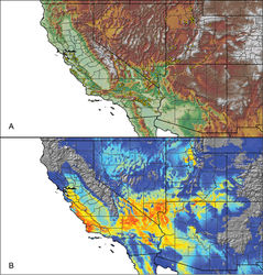
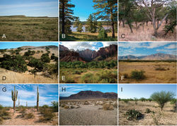
Aphonopelma iodius has a wide distribution that stretches across several diverse habitats from the Bay Area of California, south along the Coast Ranges across the Transverse Ranges, into the Mojave Desert (Fig. 1H), and north throughout the Great Basin Desert of Nevada, northwestern Arizona, and Utah (Fig. 67). Aphonopelma iodius has been found in the following Level III Ecoregions: Sierra Nevada, Central California Foothills and Coastal Mountains, Central California Valley, Southern California Mountains, Mojave Basin and Range, Sonoran Basin and Range, Central Basin and Range, Arizona/New Mexico Plateau, Northern Basin and Range, Wasatch and Uinta Mountains, and Colorado Plateaus. Aphonopelma iodius can be found in syntopy with a number of species across its distribution including Aphonopelma atomicum , Aphonopelma eutylenum, Aphonopelma icenoglei , Aphonopelma johnnycashi , Aphonopelma joshua, Aphonopelma mojave, Aphonopelma prenticei , and Aphonopelma steindachneri. The breeding season, when mature males abandon their burrows in search of females, occurs from late summer to early fall (generally August–November).
Conservation status
Aphonopelma iodius is one of the most widespread and abundant species in the United States. The species is secure.
Remarks
Aphonopelma iodius is a problematic species. As presently defined, there are no major morphological features that can be used to distinguish Aphonopelma iodius from its sister lineages, and there is not enough evidence at this time to allow us to recognize cryptic diversity within the Aphonopelma iodius lineage (except for the geographically, genetically, and morphologically distinct Aphonopelma johnnycashi). During evaluation of traditional two-dimensional PCA morphospace and three-dimensional PCA morphospace (PC1~PC2~PC3), males and females of Aphonopelma iodius do not separate from any of the other species in the iodius species group (Aphonopelma chalcodes, Aphonopelma eutylenum, Aphonopelma johnnycashi), but do separate from Aphonopelma steindachneri and their syntopic miniature tarantulas (Aphonopelma atomicum, Aphonopelma icenoglei, Aphonopelma joshua, Aphonopelma mojave, and Aphonopelma prenticei) (see Suppl. material 2). PC1, PC2, and PC3 explain ≥95% of the variation in all analyses.
We examined the holotypes and freshly collected topotypic material of Aphonopelma brunnius, Aphonopelma chamberlini, Aphonopelma iviei, Aphonopelma lithodomum, Aphonopelma smithi, and Aphonopelma zionis. We also examined the holotypes and freshly collected topotypic material of three previously synonymized species: Aphonopelma angusi, Aphonopelma melanium, and Aphonopelma nevadanum. Our morphological and molecular analyses fail to recognize these nine species as separate, independently evolving lineages. As a consequence, we consider Aphonopelma brunnius, Aphonopelma chamberlini, Aphonopelma iviei, Aphonopelma lithodomum, Aphonopelma smithi, and Aphonopelma zionis junior synonyms of Aphonopelma iodius and confirm the synonymizations of Aphonopelma angusi, Aphonopelma melanium, and Aphonopelma nevadanum proposed by Prentice (1997)[3]. With additional sampling, however, it is possible that Aphonopelma nevadanum will be removed from synonymy.
Prentice formally changed the spelling of Aphonopelma iodius to Aphonopelma iodium because the gender is neuter. But, Chamberlin & Ivie (1939, pgs. 5–7) described Delopelma (Aphonopelma) iodius as “...easily distinguishable from melanius, which it apparently resembles most closely, by its rich rust color as contrasted with the dark metallic color of melanius.” It is also noted that in Chamberlin (1940)[4], the key uses the word “blackish” to describe Aphonopelma melanius (since synonymized). Because Aphonopelma iodius (the more rust colored of the two) and Aphonopelma melanius (the more blackish of the two) were described next to each other (Chamberlin 1939), Aphonopelma iodius is the correct neuter comparative (pers. comm. H.D. Cameron).
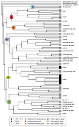
Mitochondrial DNA (CO1) identifies Aphonopelma iodius, as presently defined, as a polyphyletic species with individuals grouping together with members of Aphonopelma chalcodes and Aphonopelma johnnycashi (Fig. 7). A number of these lineages were previously identified as putative novel species (Hamilton et al. 2014[5]). While nuclear DNA also identifies Aphonopelma iodius as a polyphyletic group, it is providing more insight into the evolutionary history of the Aphonopelma iodius lineages (Fig. 8). Aphonopelma iodius comprises two monophyletic groups (one comprising nominotypical Aphonopelma iodius material from Utah and another comprising all remaining material). More specimens need to be sequenced for future coalescent species-tree analyses and gene flow evaluation before taxonomic change can be recommended. These results once again highlight how CO1 is not effective at accurately delimiting species boundaries within this group.
Taxon Treatment
- Hamilton, C; Hendrixson, B; Bond, J; 2016: Taxonomic revision of the tarantula genus Aphonopelma Pocock, 1901 (Araneae, Mygalomorphae, Theraphosidae) within the United States ZooKeys, (560): 1-340. doi
Images
|
Other References
- ↑ Chamberlin R, Ivie W (1939) New Tarantulas from the Southwestern States. Bulletin of the University of Utah 29: 1–17.
- ↑ 2.0 2.1 Cooke J, Roth V, Miller F (1972) The urticating hairs of theraphosid spiders. American Museum Novitates, 1–43.
- ↑ Prentice T (1997) Theraphosidae of the Mojave Desert west and north of the Colorado River (Araneae, Mygalomorphae, Theraphosidae). Journal of Arachnology 25: 137–176.
- ↑ Chamberlin R (1940) New American Tarantulas of the Family Aviculariidae. Bulletin of the University of Utah 30: 1–39.
- ↑ 5.0 5.1 Hamilton C, Hendrixson B, Brewer M, Bond J (2014) An evaluation of sampling effects on multiple DNA barcoding methods leads to an integrative approach for delimiting species: A case study of the North American tarantula genus Aphonopelma (Araneae, Mygalomorphae, Theraphosidae). Molecular Phylogenetics and Evolution 71: 79–93. doi: 10.1016/j.ympev.2013.11.007
![Figure 7. Maximum Likelihood inferred CO1 gene tree phylogeny for the 1,032 Aphonopelma specimen dataset. Species delimitations followed the integrative methodological approach outlined in Hamilton et al. (2014)[5]. Black circles denote bootstrap support ≥ 80%; white squares denote bootstrap support ≤ 80%. White triangles indicate species clades supported with ≥ 80% bootstrap support; grey triangles indicate lineages with putative mitochondrial introgression events. Asterisks at the tips of branches indicate undescribed diversity.](https://species-id.net/o/thumb.php?f=Zookeys-560-e6264-g007.jpg&width=188)
