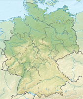
File:Germany, Federal Republic of location map September 1955 - December 1956.svg

| This media item is originally from http://commons.wikimedia.org/wiki/File:Germany,_Federal_Republic_of_location_map_September_1955_-_December_1956.svg, last uploaded by BetacommandBot; it was copied to a local repository as a caching mechanism to speed up page rendering and to prevent links to break when media items are renamed on commons. For a full list of earlier authors and contributors please refer to the file version history and the metadata version history in the repository from which this media item has been copied.
Below you find the original information from the metadata page at the time of copying (2013-06-09, 06:01): |
move approved by: User:Enomil
This image was moved from File:Germany, Federal Republic of location map September 1955 - December 1957.svg
Summary
| Description | Deutsch: Positionskarte der Bundesrepublik Deutschland. Diese Karte zeigt die Bundesrepublik im Gebietsstand zwischen September 1955 bis Dezember 1956.
Quadratische Plattkarte, N-S-Streckung 150 %. Geographische Begrenzung der Karte:
English: Location map of Federal Republic of Germany. Map shows West-Germany as of September 1955 till December 1956.
Equirectangular projection, N/S stretching 150 %. Geographic limits of the map:
|
||||||||
| Date | Created in 2009 | ||||||||
| Source | own work, based on File:Germany location map.svg | ||||||||
| Author | TUBS | ||||||||
| Permission (Reusing this file) |
|
||||||||
| Other versions |
Deutsch: Bundesrepublik Deutschland (vor 1990 nur West-Deutschland):
Deutsche Demokratische Republik (mit BRD im Ausschnitt):
Ostdeutschland (vor 1990 Deutsche Demokratische Republik):
Deutschland zwischen Mai 1945 und Oktober 1949:
Thematisch: |
File history
| date/time | username | resolution | size | edit summary |
|---|---|---|---|---|
| 2009-01-18T03:27:48Z | User:TUBS | 1075×1273 | 496.72Kb | {{Information |Description=Germany,_Federal_Republic_of__location_map_April_1952_-_August_1955 |Source=own work |Date=2009 |Author=[[Author:TUBS]] |Permission= |other_versions= }} |
File history
Click on a date/time to view the file as it appeared at that time.
| Date/Time | Thumbnail | Dimensions | User | Comment | |
|---|---|---|---|---|---|
| current | 05:01, 9 June 2013 |  | 1,075 × 1,273 (497 KB) | Media-caching-bot (Talk | contribs) | {{Cached Commons Copy|file=Germany,_Federal_Republic_of_location_map_September_1955_-_December_1956.svg|lastuploader=BetacommandBot|time=2013-06-09, 06:01}} move approved by: User:Enomil This image was moved from [[:File:Germany, Federal Republic of |
- You cannot overwrite this file.
File usage
The following 27 pages link to this file:
- File:Deutschland Autobahnen.svg
- File:East Germany location map.svg
- File:Germany, Federal Republic of location map 23 May 1949 - 6 Oct 1949.svg
- File:Germany, Federal Republic of location map April 1952 - August 1955.svg
- File:Germany, Federal Republic of location map December 1950 - April 1952.svg
- File:Germany, Federal Republic of location map January 1957 - October 1990.svg
- File:Germany, Federal Republic of location map October 1949 - November 1950.svg
- File:Germany, Federal Republic of location map September 1955 - December 1956.svg
- File:Germany, German Democratic Republic location map January 1957 - October 1990.svg
- File:Germany, German Democratic Republic location map July 1952 - January 1957.svg
- File:Germany, German Democratic Republic location map October 1949 - July 1952.svg
- File:Germany, German Democratic Republic location map w·o FRG July 1952 - October 1990.svg
- File:Germany, German Democratic Republic location map w·o FRG October 1949 - June 1952.svg
- File:Germany, German Demorcratic Republic location map w·o FRG July 1952 - October 1990.svg
- File:Germany, location map (SBZ perspective) 23 May 1949 - 6 Oct 1949.svg
- File:Germany2 location map.svg
- File:Germany location map.svg
- File:Germany location map 23 April 1949 - 22 May 1949.svg
- File:Germany location map 8 Jun 1947 - 22 Apr 1949.svg
- File:Germany location map April 1992 - July 1992.svg
- File:Germany location map August 1992 - June 1993.svg
- File:Germany location map July 1993 - December 2009.svg
- File:Germany location map October 1990 - March 1992.svg
- File:Germany location map labeled 8 Jun 1947 - 22 Apr 1949.svg
- File:Relief Map of Germany.png
- File:Relief Map of Germany.svg
- Template:Germany location map/other versions
Global file usage
The following other wikis use this file:
- Usage on biowikifarm.net


