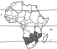
File:Map Combretum erythrophyllum.gif
From OpenMedia
Revision as of 21:20, 24 October 2014 by Michel Chauvet (Talk | contribs) (distribution map in Africa Category:PROTA map)
Map_Combretum_erythrophyllum.gif (200 × 174 pixels, file size: 8 KB, MIME type: image/gif)
distribution map in Africa
File history
Click on a date/time to view the file as it appeared at that time.
| Date/Time | Thumbnail | Dimensions | User | Comment | |
|---|---|---|---|---|---|
| current | 21:20, 24 October 2014 |  | 200 × 174 (8 KB) | Michel Chauvet (Talk | contribs) | distribution map in Africa Category:PROTA map |
- You cannot overwrite this file.
File usage
There are no pages that link to this file.
